October 21, 2015

Outback 3 Duncan Dunnart and the Moon Rocks

It was early morning in Cloncurry, the 'Friendly Heart of Outback Queensland'.
Cloncurry was deemed the state's friendliest town in 2013, hence its slogan. 'The Curry' is rich in history: it saw the foundation of the Royal Flying Doctor Service in 1928, and was the destination of the first Queensland and Northern Territory Aerial Service flight. The original Qantas hangar is still in use. Cloncurry lies 400 kilometres south of the Gulf of Carpentaria, on the Cloncurry River and at the junction of the Flinders and Matilda highways. Explorer Robert O'Hara Burke named the River after his cousin Elizabeth Cloncurry, who lived in his home county of Galway.

Six years after Burke and Wills, Ernest Henry came this way looking for grazing land in 1867. Instead he found large deposits of copper: his Great Australia Mine is still in operation today. Gold deposits were found too, in 1908, at Mount Quamby, 50 km northwest of Cloncurry. (How many place names in Queensland begin with Q? Just a thought.) The pastoral industry was also of great importance to the town, and Cloncurry had the biggest sale yards in the state's northwest. They are now mainly used for tick dipping (which, in English, means dipping your cattle to rid them of ticks).

We had woken early and were on the road – the Flinders Highway, which goes all the way to Townsville – by 07:15. There were many birds about: two flocks of Galahs, one by the roadside and one in a paddock; a gathering of Little Corellas by the road; three Brolgas; and a pair of stately Australian Bustards.
I was driving along an open road, but there was more and more roadkill, and I was reluctant to do even 80 km/hr. About 30 kilometres or so before Julia Creek we crossed the Gillat River Channels. They reminded me of Cooper Creek and my favourite Channel Country in southwest Queensland, but these channels flow northwards across the Gulf Country to the Gulf itself: I wish now that I'd paid them more attention, although they were dry and indistinguishable from hundreds of others.

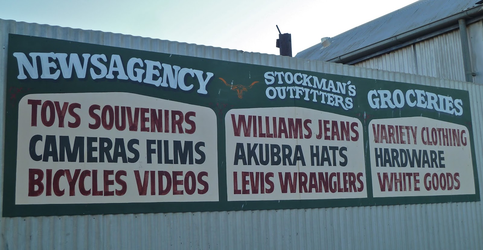
We reached Julia Creek by 09:00. Dunnart feeding-time wasn't for another hour, so we wandered down the main street and bought croissants and coffee. As usual, you can learn a lot about a town from its shop fronts.
Award-winning Julia Creek Visitor Information Centre is an attraction in its own right. In modern, well-designed units there are many audio-visual displays on the history of the town and what it's like to live in Julia Creek and the wider area of McKinley Shire today. One video featured a large number of locals vehemently denying that Julia Creek was named after the great love of Robert Burke's life, Julia Matthews, star of 'light theatre' in Melbourne. Burke and Wills never even came through McKinley Shire, they protested. I don't know why they're so worked up: it only took me a few moments to determine that, in fact, the town was named by the first settlers here, the McIntyre brothers, Duncan* and Donald, after family members.

The biggest draw At the Creek is undoutedly the Dunnart, an extremely small, nocturnal, insect-eating marsupial with sharp teeth and a pointy snout. 'They're lean, mean and rarely seen.' There are several species of Dunnart, including a Julia Creek Dunnart, found only on the Mitchell Grass plains of northwest Queensland and believed to be extinct until 1992, when a few were found locally, since when the tiny creature has been classed as Endangered. So, for the purposes of entertaining tourists, enter the Fat-tailed Dunnart. His name was Duncan. I have never seen such a tiny thing move so fast: he was a blur. I think he had ADHD. He couldn't even finish his breakfast of a few grubs at one go, but kept rushing off, then coming back and eating another morsel. His feet were unimaginably small. Apologies for the blurring, either because of poor light or fast-moving critter.
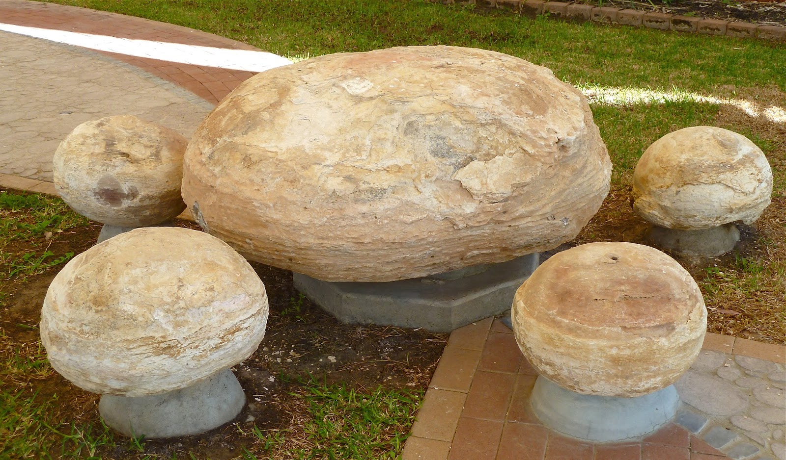
Moon Rock table and chairs
It's 400 kilometres from Cloncurry to Hughenden, where we were staying that night, so we couldn't hang around. Next up was Richmond, home of Moon Rocks and giant marine fossils, and 150 kilometres beyond, across flat plains. The Flinders was straight for such long stretches it disappeared into mirage, as did the country to either side. The number of dead roos was truly alarming.
 
 
We spent an inordinate amount of time in Richmond looking for naturally occurring Moon Rocks, as opposed to those gathered for show. It was a fruitless search. This is what I learned about them from Kronosaurus Corner, 'Australia's premier marine fossil museum'.
These round objects are a common and conspicuous feature of the region. They range from the size of a golf ball to boulders weighing several tonnes, and are found throughout the black soil of the Rolling Downs country. The nodules are concretions that formed by the accumulation of limestone cement (calcium carbonate) within mud on an ancient sea floor. They formed by chemical processes within the sediment and are not water-worn.
Under isotropic conditions – meaning the mud had the same physical properties in all directions – the nodules [more often than not] formed spherical shapes… Although the nodules themselves are not fossils, they can, and often do, contain fossils – especially shells – which are also composed of calcium carbonate. The shells formed a nucleus around which further accumulation of carbonate occurred.
Our first stop in Richmond was the aforementioned Kronosaurus Corner, where there are some truly remarkable collections of bones painstakingly placed to recreate the skeletons of mainly marine creatures but also a couple of dinosaurs. If you're wondering why you've never heard much about fossil finds or dinosaurs in Australia, or perhaps only recently, you'll find a useful fact sheet at http://teq.queensland.com/~/media/97562B802A9F429E8E120F38A5A84B9E.ashx?la=en-PH. Below is a short-necked pliosaur, a marine reptile with powerful flippers and tail that was the largest predator in the inland sea once covering the vast plains of what is now Outback Queensland. This complete Richmond Pliosaur was found on Marathon Station near Richmond in 1990. 
You can go fossil hunting at a couple of sites northwest of town: details from Kronosaurus Corner. 

We asked at the information desk where we could find Moon Rocks lying around in their natural state. A sixty-four thousand dollar question, apparently. We were directed hither and thither, but failed to find what we were looking for.
 
We went to eat our lunch by the manmade lake in Richmond, Lake Fred Tritton. I'm sure the former mayor deserved to have a lake named after him, but it is not a nice name for a lake. There were more carefully arranged Moon Rocks and a number of interesting birds.
Great Crested Grebes
We had another 112 kilometres to go to Hughenden. My friend had spotted a highlighted route to the north of the Flinders Highway, a tourist route called the Basalt Byway. We thought it would be a nice little detour to round off the day. I now know we should have started this trek from Hughenden rather than Marathon, for that is what it turned out to be. From the town there's a 95 km circuit through 'rolling landscapes of basalt walls and deep valleys', with excellent lookouts. We chose a 113 kilometre long-way-round extension to get to that circuit, but the state of the track precluded good progress. Eventually, we had to give up for lack of time, cut back to the Highway, and hence into Hughenden. So we missed the scenery and the viewpoints altogether, but the drive had been challenging, my friend had opened and closed many farm gates, and we came across naturally occurring Moon Rocks, which made everything worthwhile. Mission accomplished.
 
 
The brothers were explorers as well as pastoralists. Duncan found what he believed to be traces of Ludwig Leichhardt's last expedition, namely two blazed trees and a couple of very old horses. That was in 1864, 16 years after Leichhardt went missing. Duncan lead an expedition to the Gulf to search for him. At Bourketown Duncan learned of 'half-castes' living with Aborigines: their birth dates would have coincided with Leichhardt's expedition being in the region, if he'd followed the route he said he would.
This post was last edited on 29 November 2015


October 19, 2015

Not in Kevin's Corner

Grazier Bruce Currie talks to the ABC outside the Magistrates Court
Today some old friends and familiar faces reconvened in Brisbane's Land Court as two conservation groups and landowners from Central Queensland began a challenge to GVK Hancock's proposed Kevin's Corner mine in the Galilee Basin. Member Wayne Cochrane presided.

All objections to proposed mega mines in the Galilee, and mines anywhere else for that matter, come down to irreversible groundwater impacts. It was the same in the Alpha case of 2013 and the Carmichael case in April this year, and it is the same in the battle for the Liverpool Plains of New South Wales. Will farmers' bores dry up once the mine is operational; will spring systems cease to be; and will the Great Artesian Basin (GAB), arguably Australia's most crucially important water source, be compromised beyond recovery.

Water is unquestionably the nation's most valuable resource. This continent has an arid climate in more regions than not, and, since climate is changing, drought will become more severe and prolonged. There is currently what has been described as a Godzilla El NiƱo developing, which will exacerbate the drought already being endured by many farming communities across Queensland and other states.

Other key matters in this case are ecology, economics and cumulative impact assessment.

Appearing in Court are the North Queensland Conservation Council (NQCC) and the Coast and Country Association of Queensland (CCAQ), the latter represented by the Environmental Defenders Office (EDO), along with Bruce and Annette Currie, beef farmers from near Jericho who are once again bravely representing themselves.

Kevin's Corner mine is projected to produce 30 million tonnes of thermal coal a year for 30 years. It is situated in the south Galilee Basin, 360 kilometres southwest of Mackay. The project will have both open-cut and underground operations.

As Damian Clothier (for GVK Hancock) began his opening statement, familiar names, acronyms and issues cropped up: the Rewan Formation and Dunda Beds; disputes between expert hydrogeologists about folding, faulting and recharge; aquifer parameters and groundwater modelling; monitoring bores and trigger levels; EISs, SEISs and MES; the Co-ordinator General's conditions and the Precautionary Principle.

Member Cochrane has a very different style from the judges in previous cases I've attended in the Land Court. He frequently interjected with questions, or required clarification or elaboration. He shared his thoughts with counsel and other representatives: are cumulative impact assessments (CIAs) beyond his remit? Where is the security for landowners (with regard to unpredicted impacts on water)? Modelling is only as good as the extent to which its assumptions are based on reality. Isn't everything he's going to hear from expert witnesses speculative? (Mr Clothier preferred the word predictive.) Could Mrs Tubman (for NQCC) give him an example of a social cumulative impact?

Before Dr McGrath of the EDO began his opening statement, he raised possibly the most intriguing matter of the day, and a conundrum. References had been made earlier by Mr Clothier to how Hancock's lack of a water licence permitting, for example, any impact on the GAB, would protect landowners against an unpredicted loss of water from their artesian bores, and thus necessitate a halt to mining if it occurred. Dr McGrath pointed out that changes to the Water Act introduced by the Newman government (the contentious Water Reform and Other Legislation Amendment Act) due to take effect by default from 6 December this year unless the current Queensland government repeals them (as promised prior to its election last January), mean that mining companies will no longer be required to obtain water licences in order to extract large quantities of water for their projects. This has huge implications for the handing down of Member Cochrane's recommendations in conclusion to this case.

The day's proceedings culminated with Ms Tubman's opening statement and main concern – the failure of GVK Hancock to provide a CIA as specified in the SEIS for Kevin's Corner.

We start half an hour earlier than usual in the morning…


October 17, 2015

Outback 3 From Camooweal to Cloncurry doesn't scan

In Queensland tourist guides from a decade ago you'll find recommendations to visit Freckleton's General Store in Camooweal. From this shop it was possible, at one time or another in its long history since the early 1900s, to buy airline tickets, blankets, cow licks, drapery, equipment (all sorts), feedstuffs, groceries, hats, ices, jeans, kerosene lights, liquor, mosquito nets, needles, oil, pharmaceuticals, Queensland souvenirs, reading materials, saddles, tobacco, vehicle parts, washing machines, xylophones, yams and zips. OK, I made the last three up, but they may well have been sold. In the days before The Isa existed, this store was where everybody in northwest Queensland came to do their shopping, every-day or special-occasion.

I've been to this kind of store before in the Outback, and it's an education, not to mention the photo ops. I was therefore keen to visit Freckleton's before we left Camooweal next morning. But it was boarded up, as was the museum next door, where I had hoped to search for evidence that my explorer hero, Ludwig Leichhardt, had travelled through the Barkly Tableland on his ill-fated last expedition to the Swan River. The store closed in 2009, its elderly owner, Ada Miller (nƩe Freckleton), unable to resist the inevitable in a world of specialisation, high transportation costs, and cut-price multi-pack supermarket deals. I wonder if Blueprint for the Bush* initiatives might also include support for the continued existence of a store that supplied everything for the community and well beyond, not to mention the tourist draw. Who would want to go into The Isa by choice, I ask you?
Today Camooweal Post Office (above) is the general store. Now we all know Australian post offices don't open until 9 am. How much use is that on a summer morning when you've been up since 5 and you need milk for breakfast… and you're not a dairy farmer? 

Camooweal calls itself the 'Gateway to the Northern Territory', the border with which is 13 kilometres west of the town. We toyed with the idea of going there, but not for long: state borders have long been a source of disappointment. William Landsborough first came through this area when he was looking for Burke and Wills in 1862. The town was founded in the 1880s, and its position as a border town made it a customs collection point as well as the frontline in the battle to prevent the spread of cattle ticks across northern Australia. It was an important dipping point for large numbers of cattle being moved interstate.

Although Mt Isa wasn't founded until the 1930s, it soon outgrew Camooweal. Such is the reach of the city council's administrative jurisdiction today – roughly the size of Switzerland, they say – Camooweal is considered to be a suburb, despite being nearly 200 km away. People jokingly describe the Barkly Highway as the longest main street in the world, which seems a strange concept to me.

I liked Camooweal; I liked the idea of Camooweal. It had that prerequisite for a memorable Outback town – silently circling Black Kites. I liked its droving history. You can visit The Drover's Camp, a shed full of memorabilia on the eastern edge of town, and there's The Drover's Camp Festival every August, which we missed by about a week.

Bundaberg artist Craig Nelson created this bronze statue based on drover Sid Biondi and his horse, and donated it to the people of Camooweal in 2014. Sid was a contract drover who moved huge numbers of cattle across the Northern Territory stock routes from the 1940s to the 1960s. His father had been a pack-horse mailman in the town in the late 1800s.
And so, off to Mt Isa, 'Australia's Rodeo Capital & Premier Mining City', one sign claims. If you remember, we nearly went on last year's Outback trip, but I thought better of it. This time it had to be ticked off: the mining capital of Queensland often finds itself on lists of iconic Outback towns. There were only two things of note during the 189 kilometres: bizarre anthill adornment, and a fire at our halfway breakfast stop.
Someone – and I suspected those leaving the rest area in a Kombi Van as we pulled in – had made a fire between the two arms of a substantial forked log on the ground. There were flames when we arrived, but they had died down before we doused the smoking wood with water. There was less smoke by the time we left, but we decided to report it to Mt Isa fire services, just in case it flared up again.

Whatever way you look at it, there is no escaping The Isa's industry. What must this look like in the rain? The sign on the way in from the west – 'Birth Place of Champions' – refers to celebrities such as Pat Rafter and Greg Norman (and a whole host of other people I've never heard of) who were born here. 
The Visitor Centre in the main drag, Marian Street, was disappointing. My friend wanted samples of the ores that are the basis of the town's wealth, but they looked at him as if he was weird when he asked. The Hard Times Mine tour takes two and a half hours in 1.2 kilometres of purpose-built tunnels complete with machinery and noise (at a cost of $5 million), and you have to dress appropriately in mining safety gear and boots, as if it were real and not an experience. The shop sells hi-vis jackets for little wannabe miners.
From there we walked around the town centre, which was hot and characterless, and every time you turned a corner you could see the red-and-white-striped stack of the copper smelter, and the taller chimney of the lead smelter. The former puthered continuously. (Puther is one of many words invented by my Aunt Edith: it means the emission of smoke or fumes continuously or in regular puffs; from a car exhaust, fireplace or stack, for example.) It took ages and much asking to find a coffee shop in Mt Isa, but we did strike ore in an unlikely souvenir shop (shhh, don't tell the geologists). I badly wanted to leave town.
But before the getaway we had to drive up to the City Lookout to view the industrial landscape from a different vantage point. 
Hills of spoil
Look the other way, see no chimneys
In Welcome to the Outback, Sue Williams describes a T-shirt I should have bought myself: 'Happiness is Mt Isa in the rear-view mirror'.

A prospector named John Campbell Miles was just passing through this area in 1923 when he came across an outcrop of silver-lead ore (there is also zinc and copper). Soon, hundreds of men came to stake a claim at $1 an acre. Heat, isolation, living rough and back-breaking work made for a grim existence. Mount Isa Mines was one of three companies established the following year, but MIM quickly absorbed the other two. A town grew up within a couple of years and the railway arrived in 1929. The history of mining in Mt Isa was one of many lean years before prosperity and growth. Xstrata bought Mount Isa Mines in 2003 before merging with Glencore in 2013. Glencore Xstrata became Glencore the following year. 

There is obviously masses more to the history of Mt Isa and mining, but I am rapidly losing the will to research, just as I quickly lost interest in staying for any longer than a brief visit. Iconic Outback town some may claim it to be, but it's far from my idea of such a thing. It did, however, have circling Black Kites to commend it.

Back on the Barkly Highway, we had a new mission, to spot a Hill Kurrajong, a rare deciduous tree that is only found in shallow soil on rocky hillsides around Mt Isa and Dajarra in northwest Queensland. It is slightly bottle-tree-shaped and has bright green leaves at the end of the dry season, unlike many other trees, making it easier to identify. It didn't take long to spot a couple, from the road.
Mt Isa depressed my enthusiasm to such an extent that I didn't find the Leichhardt River on which the city sits. So I was pleased to come across an eastern branch half way to Mary Kathleen, our next port of call. There was no water in it, natch.
Then I had a bit more practice with these, including a 4-er.
In 1954, two prospectors broke down in a dry river bed. One of them swept the area with a Geiger counter, as you do. He found uranium oxide; a subsidiary of Rio Tinto mined the mineral; and a new town was built for 350 people and named after the prospector's late wife, Mary Kathleen McConachy. The UK Atomic Energy Commission provided some of the money to get the project off the ground. The mine was closed by 1984, however, as a result of the oversupply of uranium on the world market.
The town's people were not happy about having to move away when the plant and the town was sold: they'd loved living in a town equipped with many amenities that had been built to attract them in the first place.

You can still see the town's layout, but the houses have long since been dispersed. (Literally moving house is quite common in Australia.) Much more exciting, however, is the water-filled pit at the mine site. It is not easy to get to and totally out of the question without a 4WD, and even then only if you're happy negotiating steep, rock-strewn slopes. This is the creek crossing right at the beginning of the track.
Tourists are not encouraged to visit Mary Kathleen. We had to ask how to find it at Mt Isa visitor centre, and we were given this, which reminded me of a map of how to find buried treasure. You'll notice that it doesn't actually show the way to the mine site.
We missed a fairly important 'Mine' sign, a homemade job someone had stuck to a tree to be helpful, and then took another wrong turn. GPS wasn't any use because we were off track, but we measured 6.1 km from the turn-off to Mary K township, per the instructions. We met the only other visitor on the way up. I didn't think he should be there, so close to what must be contaminated water. All the trees in the water were dead, not surprisingly, but it took a while to realise, while we were walking round the pit, that there were no birds, or lizards, or insects. I think there were flies… it was hot.

The stepped rock faces of the pit were streaked with red, white, ochre and blue-green, where minerals have been oxidised. The water was turquoise and quite inviting in the heat. I can imagine some crazy Aussies would go for a dip. There was no sign of the camel on the way down.
This is the beautiful country we were in. On the way back to the Barkly, we spotted another wonderful example of the Hill Kurrajong, requiring just a little walk to reach it.
This part of northwest Queensland is, or was, big mining country. South of the Barkly Highway midway between Mt Isa and Cloncurry are the copper-rich Argylla Ranges where three towns – Bulonga, Ballara and Hightville – sprang up in the early 1900s, then died a death just as quickly after the First World War. The Ballara Heritage Trail is a 4WD track through the Ranges and the towns, and includes a rock hole and waterfall known as Fountain Springs. We had already made choices that didn't include this detour, unfortunately.

Forty-three kilometres west of Cloncurry, by the Corella River, is a memorial to Burke and Wills who passed this spot on route to the Gulf. 
Our destination for the night was Cloncurry, not Katherine**. When I booked the Gidgee Inn Motel, I'd opted to pay a bit more for what was then going to be the night after camping-and-possibly-not-showering. Plans subsequently changed, and we added Camooweal to the itinerary. So we had a pleasant room (and bathroom) with a big bed, and there was good though pricey food in the restaurant. We quickly unloaded from the car, looking forward to a beer in the bar.

The Motel was full of mine workers in shiny new utes that exhibited irritating reverse-warning noises and locking-door beeps. In the restaurant, there were uncouth, pissed poor dressers – men with tattooed legs in short swim shorts and flip-flops – who were loud laughers and didn't care. Call me a whinger, but I am simply intolerant of crass thoughtless people. These weren't the first on this trip. At the biggest Ghost Gum near Trephina Gorge in the East MacDonnell Ranges, we had just got out of the car to marvel at this remarkable tree, when a large more-truck-than-camper pulled into the car park. It created clouds of dust as it pulled up just beyond where we were standing. A large ugly brute of a man got out and started up some kind of self-inflating device on his tyres. Cue even more dust, and hideous noise in a wonderfully peaceful place. 

On that occasion we got back in the car and left: this time, we distracted ourselves trying to choose from several options for the next two days. I think it was at this juncture I first mooted the idea of extending our trip by a day.
** see Outback 3 Route revisions, June 2015