Two days, someone said; three, a friend suggested, in answer to the question, how long does it take to drive from Brisbane to Adelaide? The cities are more than 2000 km distant, so we decided three. Even 700+ kilometres a day is going some: it means constant clock-watching; stops that are few and far between; and little if any sight-seeing – if you want to avoid dusk or night-time driving, that is, with its risk to wildlife.
On Wednesday 29 July, we left bang on schedule, at 6 am. It was coming light, fine for driving through Brisbane on the Ipswich Road and Motorway, thence to the Cunningham Highway east of Ipswich. I've never seen so little traffic this side of Cunninghams Gap. It was a cold and frosty sunny morning when we stopped for breakfast on the far side, at Gladfield.
The Cunningham Highway continues to Goodiwindi, 200 km west of Warwick. We stopped at Inglewood, a little beyond halfway, for coffee. It's a pleasant little place, and Queensland's olive-growing capital. The coffee was good. At Yelarbon, 40 km further on and the first of many silo towns, we diverted on to the Border Rivers Tourist Drive, where a surprise awaited. Whoever would have expected spinifex this far east of the Outback? Although close to both, however, we never saw the border or a river.
We had to put our foot down on the Newell Highway for a few hours. Goondiwindi – bye-bye Queensland. Moree – 'Moree Plains Shire' is not a misnomer. And Narrabri – the heart of a major cotton region. Unfortunately, we didn't have time to visit the Australian Cotton Centre on the banks of the Namoi River.
To the west of Narrabri is a place that earned the crazy name of the day award. Then we reached the Pillaga, a name etched on environmentalists' hearts because of the threat posed to this vast expanse of forest and bush by the largest coal seam gas project proposed for New South Wales.
 |
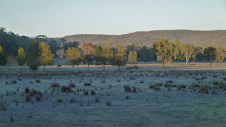
| Looking towards Mt Kaputar National Park |
We arrived at Barkala Farm and Pillaga Pottery (part of the Outback Beds accommodation network), on the very edge of Pillaga Nature Reserve, around 4. We'd planned to enjoy its remoteness for at least a couple of hours before dark. The 8000-acre property is 10 km down Dandry Road, a dirt track off the Newell Highway 23 km north of Coonabarabran.
Day 1: 692 kilometres.
Day 1: 692 kilometres.
There were pots everywhere. They're described as European inspired with iconic Australian designs. The pottery was founded in 1983. You can watch free demonstrations in the large workshop; go bushwalking or on a guided bird-watching tour; and your kids can enjoy pony rides or the 'clay-play'. There's a welcoming, relaxed atmosphere with an alternative European feel. I wish we'd been able to stay longer.
First, we had tea and scones in the Blue Wren Cafe: then we headed out to our guest house, the 3-bedroom Eagle Valley cottage, a further 2 km into the bush. A log fire had been lit for us. The fireplace was, sensibly, in the middle of the house, and that night we left our bedroom door open to continue to feel the warmth. We ate wood-fired pizza later in the Cafe, and chatted to the owner and a her friend. She runs the place as sustainably as possible: they're off the grid and self-sufficient. We found like minds when it came to politics and the environment.
First, we had tea and scones in the Blue Wren Cafe: then we headed out to our guest house, the 3-bedroom Eagle Valley cottage, a further 2 km into the bush. A log fire had been lit for us. The fireplace was, sensibly, in the middle of the house, and that night we left our bedroom door open to continue to feel the warmth. We ate wood-fired pizza later in the Cafe, and chatted to the owner and a her friend. She runs the place as sustainably as possible: they're off the grid and self-sufficient. We found like minds when it came to politics and the environment.
Next morning it was frosty in Eagle Valley. After a very short walk, we hit the road at 7.35. The country beyond Coonabarabran was a lot different from the plains and forests of the previous day: it was up-and-downy, with Black Angus and sheep grazing in a prettier landscape. To the west of us was Warrumbungle National Park, on which perches the Siding Spring Observatory. It is part of the Research School of Astronomy and Astrophysics at ANU (Australian National University).
We made a coffee stop at Gilgandra. Aah, the capriciousness of small town/bush coffee. Even if there's a Lavazza sign and you place your usual order, there's no telling what you'll get. You carry a takeaway from cafe to car with trepidation: will it be coffee as you know it or merely tasteless hot milk? (Spoken like a true urban coffee addict, I know.) Gilgandra's was the lifeless hot-milk + instant-coffee-flavoured experience.
As we approached Dubbo, progress got slower: there were more road works, fewer overtaking lanes, more caravans and trucks.
Day 2's crazy-name winner was…
Twenty kilometres north of the town of the same name, the Parkes Radio Telescope – famous for receiving and relaying television pictures of the Apollo 11 Moon landing in 1969, as told in The Dish – was a must-see up close even if there was no time for a guided tour. It is run by CSIRO (Commonwealth Scientific and Industrial Research Organisation), who, as you would expect, provide the facts and stats you need on a flying visit. The Dish is off the Newell, on Telescope Road, natch.
Back on the road, we flew through Parkes, Forbes and West Wyalong, where we deserted the Newell for the Mid Western Highway (no hyphen). We were now less than 200 km from our next overnight stop. (Since this first Outback3 post covers three days, I denied myself the opportunity of calling this stretch of adventure Hay Jude.)
As we neared Taleeban, the iPad indicated we'd shortly be crossing into the Fruit Fly Exclusion Zone. Dear gods, what action was required at this point? The tension was mounting… would there be a barrier, the fruit police, enormous bins for dumping? In reality, there was nothing. No sign; nothing. I was a tad disappointed. (Remind me to tell you one day about my first-ever encounter with fruit police, in Far North Queensland.) The next day we found out more, as we approached the Victorian border.
We were entering the Riverina, a vast area of plains in southwest New South Wales in the Murray and Murrumbidgee catchments. It supports rich and varied agriculture, but towards the more arid west is largely saltbush. Trees gave way to nicely coloured fields; silos were a different shape; everything was eventually replaced with nothing much. Rapeseed verges matched cotton bales; black cattle contrasted well. I'd heard of the Riverina; just as once I'd only heard of the Channel Country, or, still, Gippsland. Until you go, you don't know. I rather liked the sun going down on the Riverina, but I can well imagine that on a dull day it's drab and desolate.

Finally, just outside Hay, we stopped for our first glimpse of the mighty Murrumbidgee, Australia's second-longest river, which rises high in the Great Dividing Range and joins the Murray near Boundary Bend on the western Victorian border. The river flows through the heart of the Riverina and, on the map, is one of the wiggliest rivers I've ever seen. Standing in the stillness on its banks was almost soporific.
We stayed in the Bidgee Motor Inn and ate at the Riverina Hotel: both were ordinary.
Day 2: 722 kilometres.
Next morning we were leaving Hay by 8.30, having taken a look at the town and walked along the river. It was cold and still, which made for good reflections.
 |
| Lachlan Street, Hay |
 |
| Bigger word spaces might have been helpful |
The Sturt Highway west of Hay follows the Murrumbidgee for a while, but gradually the give-away tree lining diverges and you're left with a pretty empty landscape. The cotton by the roadside was the only clue to cultivation and that was gradually replaced by sheep amid hummocky grass.
While looking for somewhere to breakfast 10 km short of Balranald, we stumbled upon the beautiful Yanga Lake in Yanga National Park. Yanga Creek connects the Lake to the Murrumbidgee, and a control weir maintains water in the Lake, which is believed to have formed 128,000 years ago.
We took our fruit and muesli to the viewing deck and gazed out upon a scene of such tranquility it was hard to move on. There's a homestead, Park office and an easy walk to the water's edge.
At Balranald there's a decision to be made: continue along the Sturt Highway to Adelaide via Mildura; or take a slightly shorter, more southerly route. We headed south to the wiggly Murray forming the border with Victoria at Tooleybuc. We passed pistachio plantations at Kyalite and orchards at Piangil. Then the Mallee Highway heads west into South Australia. It takes its name from the woody plants that presented early settlers in northwest Victoria with almost impenetrable scrub in the form of multiple stems from underground tubers. Much of the region, known informally as the Victorian Mallee, has since been cleared, but remnants line the road.
The place names were entertaining: Manangatang, Ouyen, Galah, Underbool and Boinka. We stopped for picnic lunch in an almost deserted little town called Cowangie. Many of these towns along the railway track have silos that once supported vibrant communities. Most of Cowangie's homes, shops and services had seen far better days.
 |
| Liftspan bridge on the border |
 |
| Mallee (sounds like Sally) |
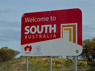
We joined the Princes Highway just before Tailem Bend in South Australia. I fancied taking a photo of the aforementioned bend close to the Murray's mouth, but it wasn't obvious how to get off the highway at the right spot. Besides which, the weather had become oppressively cloudy. By Murray Bridge we were in territory covered during our Easter trip to the Adelaide Hills. So we sped to the South Australian capital as quickly as possible. It's an easy run down from the Lofty Ranges right into the centre of the city, but the last couple of kilometres to our hotel were tortuous.
And the hotel? That'll have to wait for the next post. This turned out to have been the last picture of the day.
Day 3: 667 kilometres. In total, 2081 kilometres and four states in three days.
This post was last edited on 4 September 2015
This post was last edited on 4 September 2015


Usually, I never comment on blogs, but your article is so convincing that I never stop myself to say something about it. You’re doing a great job Man, Keep it up here is more useful information about brisbane to adelaide car transport .
ReplyDelete