As well as excellent regional maps, Hema produces 4WD Explorer Maps. We picked up the one for South East Queensland the other week when we visited a 4WD accessory shop – I can't believe I wrote that – to research a trip into the outback in June, when we'll need all sorts of equipment so that we don't do a Leichhardt and disappear into the Channel Country without trace. We bought the map for its suggestions for Straddie, Moreton and Fraser islands and Sundown National Park southwest of Stanthorpe. Being a broad-minded map, it also included Landcruiser Mountain Park.
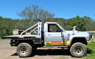
Before I describe my adventures there last Sunday, I have to explain that I am not a petrolhead with a fat-tyred, massively-high-clearance, dust-doused, mud-spattered sport ute or pickup with a blue-heeler in the tray, fishing-rod array, Sahara bars and snorkel, side rails and roof-mounted intensity lighting. I don't plan to rock-crawl or desert race – although I've always had a secret yearning to rally drive. I don't own anything like this...
I do, however, like to explore off the beaten track and reach places that ordinary cars, and therefore many people, cannot reach. Having researched Landcruiser Mountain Park, I was persuaded that it did have wilderness as well as 4WD 'events'. It claims to be a wilderness in the most important sense of the word; a fauna and flora sanctuary. Hunting and motorbiking are prohibited (mercifully).
So, off we went. Up the Bruce Highway to Caboolture, along the D'Aguilar Highway to Kilcoy, and then north up the Kilcoy-Murgon Road for 60 kilometres (16 km beyond Jimna). The landscape both along the D'Aguilar and up to Jimna was beautiful on a warm blue-sky day.
The Park is a working cattle station, although we didn't spot any cows. There are four camping grounds with gas hot showers and flush toilets. You are supposed to be able to access the camping grounds in 2WD vehicles as well as with caravans and motorhomes, but I found that hard to believe. Big rains since the end of January have chasmed even the easy 'green' tracks.
For your $25 daily entrance fee you get a map showing green, orange (rough tracks) and red (extreme), although not to scale. Zigzaggy lines along any of these routes means steep: so a zigzaggy red was probably an almost vertical, seriously rocky route. We had to keep turning back on the greens because slopes had been eroded into deep ruts and fissures, or they were muddy and rock-strewn and looked highly unstable. We had no two-way radio with us and had been told there was nobody to help if we got stuck. Someone had got bogged the previous day: the excessive rain has made creek floors unstable and/or rockier. You're advised to get out and assess a creek, even wade it, before attempting to cross, so you have some idea what lies beneath. We were never going to chance any crossings other than relative shallows.
Me not wanting to risk the crossing above – it was sandy but how solid? – meant we were unable to find the head of the Brisbane River, one of the main attractions of Landcruiser Mountain Park for me, who has a thing about the sources of rivers (see Return to the Condamine, October 2012). I have long wanted to find this particular source. Some believe it is on the slopes of Mt Stanley to the west of here, but recently I've had reason to think it was further north and east than that, in the Conondale Ranges. On Landcruiser Mountain Park's map, the source is marked right on the western boundary of the property. On some maps the Brisbane appears to be intermittent in this area, which would perhaps account for Mt Stanley's claim to fame.
In any case, we couldn't get to the point where we could even start to look for it. We were increasingly thwarted in our plans: we couldn't continue along the 'main road' through the Park, Diaper Road, because of track damage; and we couldn't find the Cowah Falls. So we gave up. There were clouds gathering, and there had been mention of a storm later in the day. This was certainly not the place to be caught in a heavy downpour. We had tested the car over difficult terrain, although I doubt we'll be back for 4WD events.
The lanscape was lovely, the weather perfect, the grass trees magnificent and the Monitor Lizards well smart.
I had been concerned there might be convoys of undesirables, but there were few people at all. One or two campers and a couple of groups of... let's call them... off-road enthusiasts. If I tell you one lot each had a windscreen banner that read 'Hard-on-em 4x4 Club' then you'll get the picture. I know little of their world but I've seen enough circle-turning on Cooloolah Beach to know that some of their manoeuvres are particularly noisy, even worse for the environment and utterly pointless. Fast, tight, 360-degree turns are also known as donuts. Landcruiser Mountain Park were at pains to point out along the tracks that Queensland's road rules apply throughout the property, and that donuts were a no-no. There are trail ethics and they're expected to be observed.
Driving off road is a uniquely Australian experience, in a big landscape that I find fascinating and truly away from it all (most of the time). I'm still not sure why we waited so long to get the right car to do it in, but living here was bound to represent a learning curve. Last Sunday certainly was.
March 20, 2013
Subscribe to:
Post Comments (Atom)


No comments:
Post a Comment