
 Back in the real world (south of the Daintree), and fortified by another delicious cooked breakfast in a cafe on Mossman's main drag, we made a second attempt to visit Mossman Gorge (above). Again it was buzzing – even at 9am on a Wednesday – but we soon realized that most people were only going as far as the lookout point and the suspension bridge. The access path is in the process of being upgraded into an elevated walkway. Will this mean admission fees, more development and even more visitors?
 It started to rain as we walked the rainforest circuit. But there were flashes of sunshine, too, which backlit splendid ferns. There were fine examples of strangler figs and buttress roots (below). Many trees in the tropical rainforest have buttresses, but the evolution of this feature is not fully understood. They provide support for a tree in what are usually shallow rainforest soils and enable it to absorb nutrients over a wider area. In places extensive buttresses formed low walls flanking our path.
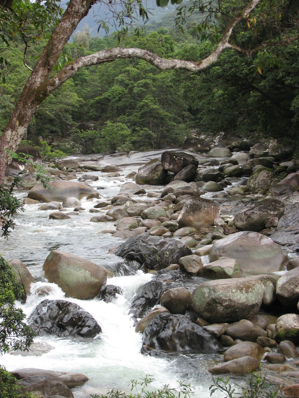
 Not far south of Mossman we turned off the Captain Cook Highway on to Mt Malloy Road. The road climbed rapidly and I looked back longingly at the coast (below). By the time we'd crossed the watershed, the vegetation had changed noticeably. The trees were shorter and more rounded and the land drier generally. We thought we'd escaped the sugarcane once and for all, but no. Just before Mount Malloy we joined the Mulligan Highway on its last leg (from Cooktown) to Mareeba.
 A few kilometres north of Mareeba, at Biboohra, a gravel road leads to the Mareeba Wetland Reserve. Several dead hogs littered the side of the road as we turned off the highway – lovely. As we neared the Reserve, we came across an emu reception committee. One almost had his head in the car window.
 These 20 square kilometres of savannah woodland and grassland were once earmarked for yet more sugarcane cultivation but were 'rescued' by the Wildlife Conservancy of Tropical Queensland on account of their significant biodiversity value. After just a couple of years, there was a marked increase in wetland wildlife in the area. The Reserve's environmental initiatives include a reintroduction programme for the Gouldian Finch (below), a beautiful, tiny little thing whose numbers have been decimated by habitat decline and capture for captivity and export. The breeding aviary is in the visitor centre where you can spot all their colour variations.
Mareeba is birdwatchers' heaven (a cormorant assortment, below).

 You can go on self-guided walks, take a kayak out on Clancy's Lagoon (above), or join organized tours by boat or on foot. You can even stay overnight in a safari lodge. We took tea and cake on the lovely viewing platform at the visitor centre and then walked round the lagoon. The centre is run by a devotee named Chook, and what he doesn't know about birds isn't worth knowing: he immediately identified two feathers we retrieved on our walk, one belonging to the Doubled-barred Finch (below).
We were now in the Atherton Tablelands and were staying right in the heart of this beautiful countryside, not far from Kairi, northeast of the town of Atherton. I was able to indulge all my Little House on the Prairie fantasies at the Barking Owl Retreat.
 Once we were installed in our idyllic little hideaway, we opened beers on the deck and watched the sun go down over our perfectly peaceful surroundings. We'd pre-ordered a BBQ hamper for supper. With steak and salad, we enjoyed a bottle of Barking Owl Shiraz (from WA). Now that's the sort of attention to detail I really appreciate, and we both subsequently voted this wonderful spot the best stay of the whole trip. The only things missing that evening were the stars and the call of the eponymous Barking Owl.
The following morning we were reluctant to leave. Little Peaceful Doves scurried about just below the deck, and cattle (with their demons) munched in the neighbouring paddock.

We changed our plans. After a quick foray into Atherton, a pleasant enough town, we headed east to Yungaburra, which is chocolate-box pretty. A short, singposted detour just outside town takes you to the outstanding Curtain Fig, which claims to be one of the largest trees in Tropical North Queensland as well as 500 years old.
 This is an example of where a Strangler Fig has engulfed its host tree which has then fallen towards a neighbouring tree. This in turn has been strangled by the Fig's roots, which drop 15 metres to the ground.
 In Yungaburra itself we walked by Petersen Creek to try to see a platypus, but we knew our chances were slim in the heat of midday. We did, however, spot a Saw-shelled Freshwater Turtle, a Purple Swamp Hen and a particularly fine example of Australian signage.
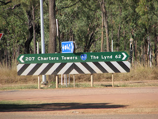
And then it was back in the direction of Atherton to the Kennedy Highway, where we turned south again headed for Mount Hypipamee National Park. The park centres on a volcanic vent that was created by a massive explosion of expanding gas from deep within the earth. The crater is less than 70 meters in diameter and has steep granite walls. Fifty-eight meters from the top of the crater there is a lake, covered with waterweed. It's about 80 meters deep. The bottom of the vent becomes a tunnel leading off into the earth goodness knows where. There's something a bit odd, or even sinister, about the place, and it feels quite remote. Apparently it was discovered in 1879 when gold prospectors nearly fell into it.
 It was while walking through the forest in the national park that we first came across cauliflory, which describes trees that produce flowers from their trunks rather than from new shoots. This phenomenon is more common in tropical rainforests, in the zone below the canopy, and it encourages pollination by a variety of animals.
 Back on the road, we were still 150 kilometres from our destination, Undara Volcanic National Park. By the time we headed west along the Savannah Way the sun was going down and keenly looking out for roos became imperative. Even when we turned off the highway, there were still 15 kilometres to go to the Undara Experience. We arrived at nightfall. And it certainly was... an experience... from the outset in the outback.
They don't do spontaneity here. Check-in was a lengthy process, involving lots of instructions and pieces of paper dotted and circled with pink highlighter. Everything has to be booked in advance. There's no waking up and fancying a bush breakfast by the campfire – unless you've booked it the previous day; no returning from Volcano Valley with an appetite for a buffet lunch in Fettler's Iron Pot Bistro – unless you'd anticipated that hunger the day before. Mind you, there's nowhere else to eat. And it isn't a place for vegetarians or families who obsess about their children eating healthily. It reminded me of a holiday camp: evening activities round the campfire, organised trips (booked in April!) and tour buses with jolly, jokey drivers. And there were lots of serious campers here, either BYO or in permanent 'swags' provided. We weren't roughing it, of course: we were in a restored railway carriage. We had our own 'ensuite', but this was not luxury accommodation by any stretch of the imagination. How I longed for my little house on the Atherton Tablelands.

Volcano Valley was something else, however. And our 'bus driver' was in fact a Savannah Guide. He spotted no fewer than five different types of roo during the four hours we were with him (Eastern Grey, Mareeba Rock Wallaby, Common Wallaroo, Antilopine Wallaroo, and Pretty-Face).
I didn't really know what a lava tube (cave) was before I got here, so a word or two of explanation... About 190,000 years ago, Undara Volcano erupted. This volcano was a shield volcano so lava didn't explode out of the top of a cone; it poured out, a bit like treacle, and covered an area of some 1,500 square kilometres. The lava tended to be channelled into water courses, one flow extending for 160km. The lava on the tops and sides of the flows cooled with exposure to the air and the earth of the channels and eventually hardened, forming tunnels through which lava still flowed until it drained away. Some of the roofs collapsed, creating entrances to the tubes. We clambered down into three.
I didn't really know what a lava tube (cave) was before I got here, so a word or two of explanation... About 190,000 years ago, Undara Volcano erupted. This volcano was a shield volcano so lava didn't explode out of the top of a cone; it poured out, a bit like treacle, and covered an area of some 1,500 square kilometres. The lava tended to be channelled into water courses, one flow extending for 160km. The lava on the tops and sides of the flows cooled with exposure to the air and the earth of the channels and eventually hardened, forming tunnels through which lava still flowed until it drained away. Some of the roofs collapsed, creating entrances to the tubes. We clambered down into three.

In places, minerals have leached through the soils above the tubes and been redeposited, creating impressively coloured ceilings.
 The tour was informative and thoroughly enjoyable. Above ground, our Savannah Guide pointed out interesting plants as well as animals. Now I can add Giant Spear Grass to my AAFF (Amazing Australian Fauna & Flora) list. This tussocky grass grows up to two meters tall, and when its sharp bristles dry out they curl themselves into knots, which burn well on the barbie, our Guide told us. The bristles, or awns, often get caught in sheep's wool and can even worm their way through skin, sheep's and human. He also showed us a Cooktown Ironwood tree, with its distinctive crocodile-skin bark. It's foliage is extremely toxic (to animals).
There were lots of opportunities to spot the roos (below), and, when we stopped for coffee and scones (!), the chance to use a dunny (below but one). This was a first. Now, while I enjoyed the view from a loo, I did find having to cough continuously, so that anyone approaching would know it was occupied, a bit of a distraction.


There are a number of self-guided bush walks at Undara. After lunch we opted for the 4-km Atkinson's Lookout track, which was easy going, though it was quite hot. The silence and the solitude were awesome. More pictures...


If you're one of those people who, when doing psychological tests, prefers to be a solitary eagle on a mountain top than a penguin on a crowded beach, then this is your country. There is nothing for miles and miles and miles and I love that fact. For the last word on Undara, I leave you with the chap who, with his mates, found it funny spoiling our lie-in.

Our trip was about to enter it's final stage: the long drive home to Brisbane. We were up with the Kookaburras and bush-breakfasting (below) – with the car packed – by 7am.

We'd been warned about roadwork on the road south – the upgrading of the Kennedy and Gregory developmental roads from one sealed lane to two – but we could never have been prepared for its extent. Because we were driving the Great Inland Way, we weren't prepared for just one sealed lane either. The gravel either side was fine to drive on but not when the oncoming vehicle was a 50-metre-long road train with no inclination to slow down. (Our car bore witness to this daunting experience in the form of a cracked windscreen and dented, chipped bodywork.) The distance and estimated travelling time for the day (Undara to Clermont, 731km/8 hours and 53 minutes) were dependent upon being able to drive at the speed limit, but after only a short distance we were wondering whether we'd make Clermont that day: where the road had been recently resurfaced we were down to 15kph. The work did end at last, however, and the joy of an open road through next-to-nothingness was restored.

The faint grey band on the horizon in the picture above turned out to be fog, which added to the fun of the next stretch of roadwork. We couldn't think of any meteorological reason why it might have formed: it wasn't a chilly morning.
There was very little settlement along our route, although we spotted one or two interesting locals. We marked progress by clocking turn-offs and the odd signpost. But sometimes it was difficult to pinpoint exactly where we were on the map.

Our target was Charters Towers for lunch. Charters Towers stands where the Flinders Highway crosses the Gregory Developmental Road, and on the map it really does look as if it's in the middle of nowhere. But the town was the centre of a gold rush at the end of the 19th century, and many opulently styled buildings reflect the town's wealth at that time. We walked up and down Gill Street, the main thoroughfare. The post office has a splendid clock tower that dominates the town: the clock came from England in 1898.

 And one sign caught our eye. Obviously this nightspot sets high sartorial standards.
We couldn't stop for long: we picked up some lunch and drove on, eating it by the roadside on the next leg. Soon it clouded over. Driving through nothing-muchness is more visually interesting in sunshine.

There was so much roadkill throughout the entire drive we concluded that looking out for wildlife was not just a dawn or dusk activity. You could only relax (slightly) where there was fencing, although that wouldn't stop a bounding roo. We continued our one-and-a-half-hour driving stints all the way.
Our motel in Clermont – we finally arrived just before nightfall – provided a fairly ordinary room but a good restaurant. We drank a decent Pinot with delicious battered barramundi and chips and salad. We attempted to walk into town afterwards for some exercise, but Clermont is a stretched-out town with wide avenues and we soon gave up. It was also remarkably chilly.
There was a gloriously sunny start to the next day, but it was only 3 degrees as we packed the car – the coldest it had been since we arrived in Australia. Motel management had omitted to tell us when we checked in that milk was not provided in the rooms, not even those funny little pots of UHT milk. We only discovered the next morning that we didn't have milk for tea. Breakfast was not served until 7.30, it being Sunday, and we had to wait until reception opened at 7 in order to pay and leave as soon as possible. So we hit the road five minutes later cold, hungry and with not even a cup of tea to have started the day on the right note. (I am told I'm best avoided if I haven't had my tea.) And it was foggy, so we had to be extra-specially roo-alert.

We had another day's hard drive ahead of us (Clermont to Agnes Water 595km; 7 hours 11 minutes), but top priority was finding breakfast. The town of Emerald came up trumps – in the form of an open bakery where we could sit and wolf down coffee and croissants and buy sandwiches for lunch. Feeling a lot readier for the rigours of the day, we hit the Capricorn Highway (although this pic was taken later).

We were in coal country, big time. The Mining Trail runs from our stopover, Clermont, to Hay Point on the coast 40km south of Mackay. This otherwise small town has two coal terminals that make it one of, if not the largest coal-exporting port in the world. Our next port of call was the Blackwater International Coal Centre, 72 km east of Emerald. This was an interesting place, with so much information – from the formation of coal deposits to methods of mining, the uses of coal and the development of clean-coal technology (this last bit especially was a big PR exercise on behalf of the Australian coal industry). Regrettably, once again it was quite expensive to get into a place of interest.
The coal haul railway shadows the Capricorn Highway all the way to Rockhampton and then south to that other great coal-exporting port, Gladstone. We saw many coal trains trundling eastwards and a few empties coming the other way.

But before Rockhampton another distraction - Mt Hay Gemstone Tourist Park. We were here for thunder eggs, spherical rocks formed in lava flows. When they are cut open, thunder eggs reveal all sorts of mineral growths and crystals that were formerly bubbles in the lava before it cooled.

My friend bought the two above from a rock shop in Brisbane which is when we made a mental note to come here, realizing it would be on our route. We didn't have the time or the inclination to go fossicking – only small thunder eggs are to be found on the mountain these days – but there were lots of other temptations, especially in the rock garden.
Mt Hay


We still had more than 200km to go so we had to step on it. Close to Rocky, we turned south on to the Bruce Highway at the roundabout where we'd spotted the first plastic, monumental cow on our journey north. So, now it really did feel as if we were headed home. But there was still one more night; one more detour off the highway; one more place to explore and in which to pretend we didn't have to go back to Brisbane.
That detour was to Agnes Water, reputed to be named after a schooner that disappeared in nearby Pancake Creek on its way from Mackay to Brisbane in 1873 without trace of ship or passengers. We arrived about 4pm and had tea at a beach cafe before checking into our motel.

Agnes Water has a twin, Town of 1770, which is 6km further up the coast and the point where Captain Cook (him again) first landed in Queensland. Seventeen Seventy is where we headed for dinner at The Tree, a recommendation. And indeed it was one of the best meals of the trip - coral trout with Asian-style rice. I had feta salad to start; my friend had prawns. Our motel room was spacious and modern.
So dawned the last morning. We pootled into 1770 again and looked at the sea...


...and then returned to Agnes for our last wonderful cooked breakfast and coffee, at Rock Latino Caffe. It was a beautiful morning - sunny and warm. I insisted on heading for the beach, where I would have hung on for hours had my friend been game to postpone the inevitable. We sat for a little while. The sun was almost hot enough to burn skin. It was 10.30 on Midwinter's Day, 21 June. Our last beach.

Agnes Water to Brisbane 472km; 7 hours 12 minutes. In fact, we were advised not to return to the Bruce Highway at Miriam Vale but to head due south to Bundy (Bundaberg) - home of the famous, but I have to say fairly disgusting, rum - and to the highway from there. The road was in dire need of resurfacing but the countryside was very pleasant. As we neared Bundy dark-leaved macadamia and avocado trees replaced sugarcane, which of course had quietly made a reappearance as we came out of the outback. We stopped at a garage store and stocked up on pineapple, apples, tomatoes, macadamias and bananas. The lady explained that cane is being substituted by the trees we'd spotted as Australia finds it cannot compete with other sugar producers in the world market. Every cloud...
I made one last attempt to sabotage our return home by suggesting a longer, further-inland route from Childers to avoid repeating our outward journey. But we stuck to Bruce. It was very very busy, mainly with lucky wotnots heading north.
My friend and I have a couple of traditions at the end of a trip: first, we identify the best in a number of categories. So, with my choices listed first and those of my friend second: the Best Place/Location was Cape Tribulation/Cooktown; Best Accommodation was Barking Lodge Retreat in Atherton (both of us); Best Meal was tomato soup and pork chop at Castaways in Mission Beach/tiger prawn fettuccine at Whet in Cape Tribulation; Best Experience was the 4WD trip to Cooktown/Great Barrier Reef; and Best Wildlife was the coral and fish on the reef/crocodiles in Cooper Creek.
Our second tradition is delightfully decadent: we always go out for dinner the night we get back from holiday. It helps to ward off deflation and renders shopping and cooking unnecessary for another day. On this occasion, we had another reason: it was the winter solstice. Since we came to Australia at the end of December, it was our second consecutive winter solstice. I wonder if that will ever happen again.
A great trip.


No comments:
Post a Comment