September 9, 2014

Outback 2: and so to Birdsville

It was day 7, but the sheer joy of setting out on a fine morning for yet another adventure in a strange but alluring landscape hadn't worn off one bit. It may sound crazy to say I felt at home in Boulia after only two days, but it doesn't take long to get into a routine – the general store to pick up provisions, the pub for a supper special, the service station to fill up with diesel. And it's easier when there's little or no choice. My feelings were the same in Winton.

We made an early start. Not by design, but because an inconsiderate couple had parked their huge f**k-off truck right outside our cabin rather than their own, and they left at 5 am, having walked around on gravel and closed car doors for a while before that. Another idiot a few minutes outside town gave us something to worry about. Although there was ample bitumen for the two of us to pass each other on the Diamantina Developmental Road, he insisted on driving on the gravel verge, without reducing speed, throwing up stones, one of which hit the windscreen with a loud – and literal – crack. Throughout the trip, we couldn't understand this exaggerated and completely unnecessary manoeuvring. On developmental roads – where there is often a single central strip of bitumen – we would pull over left to allow trucks or caravan-pullers to stay on the sealed bit. But no, they veered to their left, often destabilising those with trailers. Is it overdone politeness? Is it just what people do here? Why?

My friend had received a thunderstorm warning for the Channel Country on his weather app. We had a cloudless sky, however. And, almost immediately, a gathering of Brolgas. They were just the start of a bird display that included large flocks of Little Corellas, Budgerigars, Galahs and Cockatiels; six Australian Bustards; finches, swallows and Willy Wagtails (where in Australia don't you see Willy Wagtails?); crows and eagles. And that was all before breakfast.
We were entering Mitchell Grass country, first identified by explorer Thomas Mitchell in 1835 near Bourke in New South Wales. In fact, Queensland has the largest extent of these naturally treeless plains, considered to provide some of best natural pasture possible. The grass does well as long as grazing is properly managed; it regrows rapidly after rain, and is high in nutrients. Individual grass plants may live for up to 30 years, yet only produce seedlings once or twice. Cattle grazing and sheep and wool production have been key to the Outback economy since the first settlers pitched up in the state's west. 

Trees are only to be found along creek lines where they offer welcome shade for stock in the hot summers. Out on the grasslands, the dark clay soils absorb water when it rains, but as they dry out they shrink and crack, making it difficult for trees to establish root systems. Small animals shelter within the cracks, however. Well-intentioned but unknowing landowners and government departments over the years introduced invasive weeds such as Prickly Acacia in the hope they would provide shade and fodder. Now pastoralists take measures to control their spread.

Roughly on the border of Boulia and Diamantina shires is the Vaughan Johnson Lookout. You may not know where that border is – it's just over halfway between Boulia and Bedourie – but look out for a picnic shelter standing alone and windswept on a slight rise to the left of the road. It's just beyond a narrow track off to the right and up to the Lookout. Although the Lookout is on the Marion Downs property, it is named after the Member for Gregory (when it was opened in 2012) in recognition of his contribution towards getting more roads sealed in western Queensland. 

There was lots of information about the history of pastoralism and transportation in the west, and a loo with a view. The Mitchell Grass plains are vast and uncompromising: in the furthest distance you could just make out tree-lined Eyre Creek. It was the sort of vista you're compelled to keep snapping, even if you've already got many similar shots… just in case you never see anything quite like it again.
It got a lot sandier the nearer we got to Bedourie; and distant landforms once again became indistinct and mirage-like. We'd been told in Middleton that Bedourie is prettier than Birdsville. And it is. But our impression was coloured somewhat by the fact that the Royal Hotel, dating from 1880, was unable to serve us coffee; not that the surly serving girl cared. I concluded that the best thing about the place was its corrugated roof.  
It was siesta time for the many Little Corellas.
There were a number of points of interest from then on en route to Birdsville. Bedourie is on Eyre Creek, but there it was pretty dry –  I still can't stop comparing dry channels – in contrast to the crossing at Glengyle. I couldn't quite conceive of a station as big as the sign described. Its permanent waterholes and flood plain pastures made it an attractive property for Sidney Kidman to acquire in 1903.
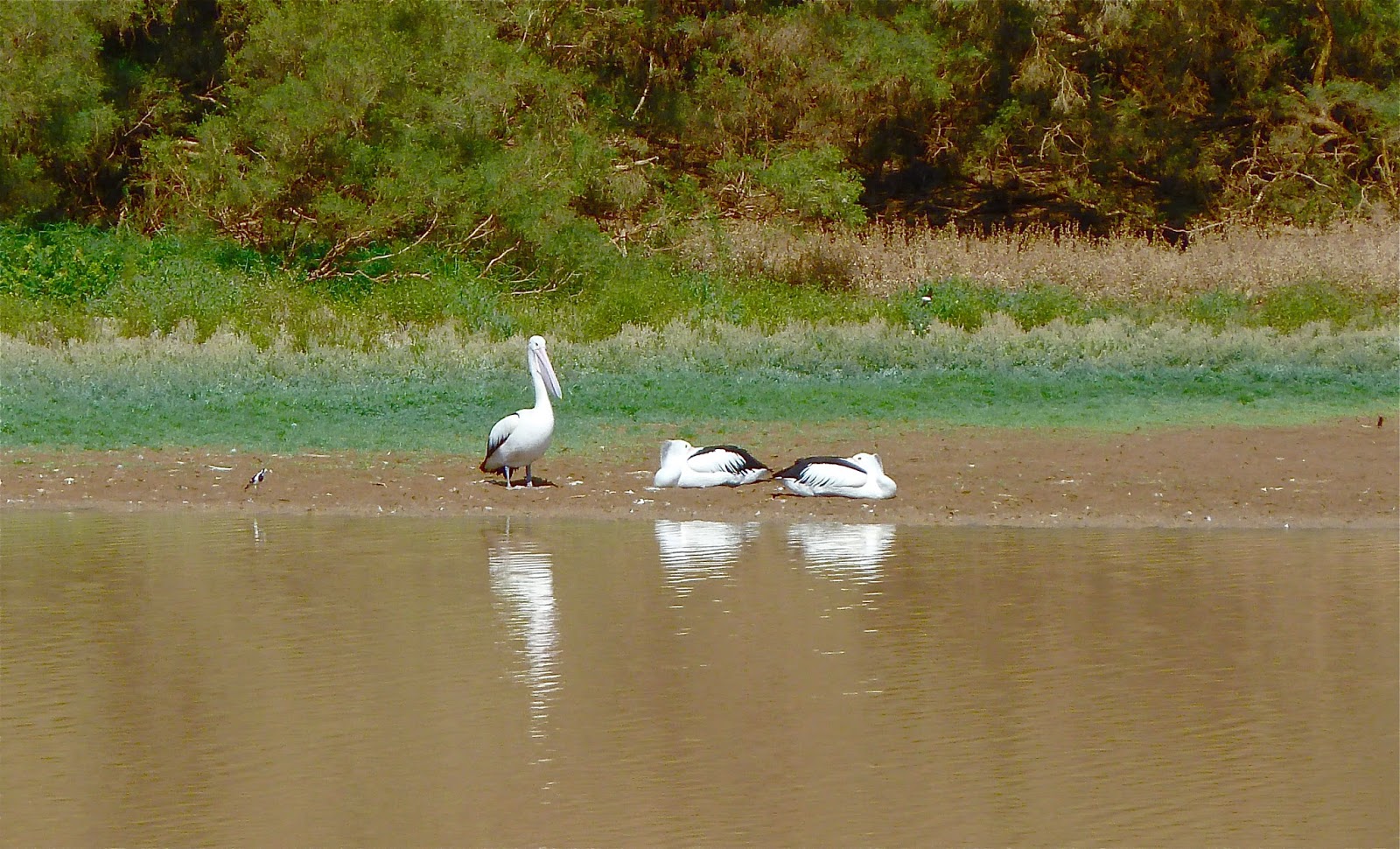
Cuttaburra Crossing, another permanent waterhole, is a little further south. We pulled into a lay-by just beforehand, thinking we were there, and were a little disappointed to find only a shy pelican and the ubiquitous White-necked Heron. (Only now have I spotted the cow in the picture.) After lunch, we continued down the road and soon came upon the actual crossing, busy with birds such as ducks, pellies, both Royal and Yellow-billed Spoonbills, herons, eagles and a Nankeen Kestrel. 
Cuttaburra lies between Lake Koolivoo and Lake Machattie. You can make a 60-km detour around the latter, from King Creek Crossing. When Machattie contains lots of water, it's claimed to be the largest pellie breeding area in Australia, but I have heard that said about other watery locations, namely one of the lakes in Currawinya National Park, north of Hungerford on the Queensland/New South Wales border. We decided against the detour, partly because we'd seen lots of birds at Cuttaburra; we weren't sure there was any water in the lake; and one description of the route mentioned lake 'glimpses'.

The Eyre Development Road (from Bedourie to Birdsville) became increasingly tiresome, with it's alternating sealed and highly corrugated sections. I later read about Royal Mail Service No 276, from Boulia to Bedourie, and it struck a chord.
Eddie Miller, overseer of Royal Mail Service No 276, had a pretty easy job on paper. All he had to do was load his truck with mail, provisions and passengers in Boulia on Thursday, drive 247 km south to Glengyle Station, stopping overnight at Bedourie, and return to Boulia on Saturday arvo, a trip of 494 km and three days in which to do it. But you don't get the real picture until you learn that the roads in Eddie's day were pretty crook, and that was in an extremely good season. Eddie used to tell the story of another old Channel Country mailman and his passenger driving through a blinding dust storm at night, and the passenger asking how the hell the mailman knew where the road was. 'When I get on to some smooth going I know I'm off the road for sure,' was his reply.
There was another treat in store before we reached Queensland's most iconic Outback town. About 12 kilometres north of it is a stand of uncommon Waddi trees. They are tall (3-4 metres) and as such look rather out of place compared with most vegetation in these arid lands. Most are between 500 and 1000 years old; they are very slow growing. They resemble Casuarinas, but more raggedy.
 
You don't need to know the address of the Birdsville Hotel: you can't really miss it; and you'll almost certainly have seen a photograph of it somewhere before. You could almost be forgiven for thinking the town itself (top of page) looks a bit sparse and bleak, if it wasn't for the excitement of having finally got there.
Seated outside was a cowboy who looked as though he'd nodded off in the late afternoon sun. But in fact he was checking his phone. Of course he was. There was mobile reception and wifi here, as there had been in every town we'd stayed in so far on the trip. Every evening I was able to post photos hot off the camera; all that day's action on Facebook within hours, if I wanted.

I hoped all my illusions of remoteness weren't going to be wrecked by the reality of comms in the furthest-flung Outback towns.
This post was last edited on 19 September 2014


September 2, 2014

Outback 2: The remote and beautiful Diamantina

The Min Min aside, Boulia is probably best known for its camel racing, in July. Camels were first introduced to Australia, South Australia, in the 1860s, to be used as pack animals and for riding by explorers and settlers. They were brought by Afghan and Indian traders. When cars and trucks became popular after World War 1, the 'Afghans', as the traders were collectively known, went home, and many camels were left to roam the continent's interior, thus joining Australia's long list of problem ferals. An extensive culling programme had to be implemented in 2013. Even after years, it still seems highly improbable to me to spot a camel in the Australian landscape.
Boulia is a last outpost of civilisation before even more remote country stretching west to the border with Northern Territory and beyond. It has an extremely broad main drag, Herbert Street, that was never even remotely busy while we were there. We stayed in the Desert Sands Motel, which I would recommend. It was good value, comfortable and pleasantly garden-filled. I didn't take many photographs of Boulia for some reason, except for cloud phenomena, an Outback sunset, the windmill, Galahs, and the notice on the door of the Min Min Store that I didn't see as I entered one cold early-morning. I was politely asked to remove my hood, and promptly felt like a rebellious teen.
Both nights in Boulia we ate at the Australian Hotel ('the pub'). We walked down Herbert to the sound of hundreds of Galahs loudly getting ready to roost. Like pubs all over Australia, this one offered a special every night that was well worth considering; they are usually well cooked and great value. And the 'cask' (box) wine was passable. Watching the locals was a lot more fun than the food, however, this being the place in town to hang out.

The Shire of Diamantina is as far west as you can get in Central West Queensland. There are only about 350 inhabitants but between 10,000 and 100,000 cattle, depending on the season. It does not include Boulia, but Boulia is the best place from which to visit Diamantina National Park in a day. It's only 183 km away, compared with Winton (306 km away) and Windorah (350 km). You can camp at a couple of places but there are no facilities apart from toilets, and there's no fuel. The Diamantina Visitors' Guide claims it is among Australia's top 10 national parks, as defined by the WWF. It is a remote area, however, and is not accessible via sealed roads. The route from Boulia will take you at least two hours of not particularly comfortable driving. There are deceptive bends on some creek-bed crossings where you can easily lose control if you don't slow right down. 

But the Park has one feature at least that is truly remarkable and worth the effort.

On the morning we set out, we had read storm and deluge warnings for eastern Australia. We could see the edge of a huge frontal system, complete with mackerel cloud. Since we were heading southeast, we were gaining on it for a couple of hours before it receded. 

I haven't said a lot about the volume of road kill on this trip. You see all kinds of creature that have met their maker in a violent collision with the bull bars on a wagon or a monster road train. On this gory morning not far from Boulia, several birds of prey were waiting to resume their feast of emu. Unfortunately one of them had not quite got out of the way in time himself, but not of us I hasten to add. Whereas you see lots of warning signs in the more populated areas back east about kangaroos or koalas or cassowaries, there are no wildlife warning signs in the Outback. The slaughter on the roads and tracks is just a fact of life and death in a harsh world.
Just as well I'd checked at the Visitors' Centre exactly where the turn off the Kennedy Developmental Road was, because it wasn't signposted Diamantina National Park! Springvale is a property about 20 kilometres from the Park's entrance. We stopped on the Tropic of Capricorn again, for old times' sake, and had a near miss with a family of roos. The mum looked anxious as dad and joey only just got out of the way in time. We'd been temporarily distracted by the horses, but a driver can't lose concentration for a moment, even in the middle of the day.
Once in the Park, we stopped at Gum Hole camping area, which is on Whistling Duck Creek. In a short space of time we saw perfectly camouflaged Spinifex Pigeons and Budgerigars, Diamond Doves and several White-necked Herons.
When you haven't got time to see everything, you have to make difficult choices. We decided against the 90-kilometre Warracoota Circuit Drive – which I believe would have included dune country as well as Lake Constance – in favour of Janet's Leap Lookout and Hunter's Gorge. But first there was the Ranger's office, including an information room, in the old homestead of the Diamantina Lakes pastoral station, first established in 1875, then much later purchased by the Queensland Government and gazetted as a National Park in 1993. It was destocked by 1998. Below is 'Diamantina Lakes': now I understand the use of inverted commas on many maps.
In 2001 this solar remote area power supply (RAPS) replaced a generator system. The 104 solar panels and 60 batteries provide all the power for the National Park.

In the information room there were many quotations from Alice Monkton Duncan-Kemp (1901-1988), a writer who grew up at Mooraberrie, a cattle property south of Diamantina. Her observations are evocative and insightful. These passages were written in 1933:
All the wealth and beauty of plant-life faded, almost into oblivion… Waterholes and rivers, that two years ago were yellow swirling foam-flecked rapids, were drying rapidly. August came and waned; October and November passed over with no usual break of thunderstorms. Christmas was ushered in with an icy spell. Summer passed and winter drew on. We almost gave up hope, for rain seemed as far off as ever.
With a roar the waters race down the larger channels, leaping into smaller channels and creeks and out on to the flats and grasslands. Slowing down their force, the waters creep and then seep across the country…
From the ranger's office we drove 12 kilometres or so to Janet's Leap Lookout. Another quote had set the scene for this location, by a J I Barry in 2007.
My recollection is that no rain was falling on Diamantina Lakes, but Dave raced over from his quarters and said, 'If you want to see a phenomenon, grab your binoculars and get up to the homestead. The Diamantina is coming through The Gates.' …once in flood, it plunges through Hunters Gorge a raging torrent and fills to overflowing the five channels sweeping out over the plains, devouring everything in sight. I gazed in awe. In an incredibly short space of time, none of the yards, not even a fence post, was visible.
The so-called Diamantina Gates are created by kilometre-wide narrows between the Goyder Range (Hunter's Gorge) and the Hamilton Range (Janet's Leap). The Diamantina River's braided channels are squeezed through this gap, and floodwaters funnelled to an impressive depth. As you approach the view point, the contrast between this landscape behind you…
…and the Coolabah-filled lower country, was breathtaking. Again I use that word. Not to mention the volume of water flowing across this parched country.
Below is Janet's Leap itself, but we weren't allowed to look out from there – or throw ourselves off, presumably as Janet once did. The pyramidal hill in the distance is known as Moses' Cone, which stockmen used as a point of reference as they herded their animals across channels and bush.
We retraced our steps and went round to the other side of the Gates, Hunter's Gorge. There we found another of Diamantina's many waterholes, Mundawerra, attended by hundreds of nattering Little Corellas and several pelicans. Behind it was Mount Mary, which is in the middle of the gorge. At first the pelicans were scattered and gliding peacefully or resting, but soon a group of them put on an intriguing display of synchronised fishing. We had never witnessed this before.
We hadn't seen reptiles or any other animals of the region who are specially adapted to intermittent water and unforgiving surroundings, but tend to be rather retiring: mice-like kowaris or kultarrs; or bilbies. But the extraordinary landscape – and the birds – had more than made up for the lack of other wildlife. 

I realise that this landscape is not everyone's idea of beauty. It's a million miles from picture-postcard pretty. Photographs do inadequate justice to the scale of the country and depth of colour beneath an at-times merciless sun. But I tell you, it has a power of attraction, a pulling power, that is hard to articulate. It generates a quietude; a separation from day-to-day angst and first-world preoccupations; a potion of perspective I'd like to bottle and inhale three times a day. I've only been back a week and a half, but I'd happily pack up for a return tomorrow. 

After a late lunch at the waterhole we already had to think about heading back to Boulia, across the bumpy gibber plains. By the time we got back, briefly, on to the Kennedy, we were almost dreaming of bitumen.
This post was last edited on 5 September 2014
ROUTE