June 28, 2013

Outback: Charleville to Thargo and beyond

click on pix to see them big
At 5 am I was far too excited to go back to sleep until the harp at 6. We got up and got on. It was still dark of course, but better to be heading south, however slowly, than hanging around for dawn. We crawled and peered, eyes darting. Others had not been so careful: there were recent victims on the killing trail. By 7 the sky was the same colour as the soil.
Exactly halfway between Charleville and Cunnamulla on the Mitchell Highway is Wyandra, our picnic breakfast stop. In the campsite bikies were brushing their teeth; and by the road there were funny beasts that resembled – at the time – a cross between a turkey and a sheep (Guinea Fowl). My eyes had already been imagining that bushes and stumps were roos, so anything was possible.
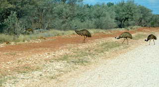
On the way to Charleville I had felt the landscape was not outbacky enough; there was too much vegetation and it was too tall. Now the sky was bigger, there were fewer trees and emus were stepping out. However, it was still too... civilised somehow.
By Cunnamulla, which has an intriguing welcome sign, we were desperate for coffee. I wandered into the Club Boutique Hotel, not realising it was being renovated. A nice lady called Peieta stopped what she was doing and made us a cup – even though the place had to be shipshape by the following day when a film crew arrived – and let us use her wi-fi to resuscitate the mapping system on the iPad that had given up the ghost a few kilometres out of Charleville, much to the consternation of my friend. We chatted for a while before leaving her to it and pressing on to Thargomindah along the Adventure Way, aka the Bulloo Developmental Road. If you're looking for accommodation in this area, give the Club Boutique Hotel a try. Peieta's done a good job restoring the hotel to its former glory.
On the way out of town we stopped by the Warrego River, which looked in rather better shape than it had in Charleville.
The landscape was definitely looking more the part; the mercury was rising; and cows had settled in the shade.
Mulga is a relatively small tree (6-9 metres) well suited to arid zones. It's upward-reaching branches catch every last drop of rain; its leaves are leathery. It grows mainly in red soil and on sandy or stony plains: the soil type determines its growth and habit. The wood is hard and is used by Aborigines to make implements. It makes excellent fence posts and burns cleanly giving out a lot of heat. If cows can't find grass to eat during a drought, they are quite partial to mulga... as well as Leopardwood and Emu Bush.

Along the Adventure Way there are interesting diversions.
Winery? On such parched earth?
We chose birdwatching. We thought we saw a Hall's Babbler. I was tempted to walk out into the sand, although the two were not connected.
This sign surprised me. I don't think I've ever seen a signpost to a litter bin before. Ever. And why there?
Not far from Thargomindah is Lake Bindegolly National Park. We stopped for lunch but unfortunately didn't have time to walk to the Lake itself. And the flies, the flies. We could see birds on the Lake through the binocs, and, from our hummocky viewpoint, the car finally looked as if it was in the Outback.
Two Wedge-tailed Eagles sat by the roadside, hoping for roadkill and an easy meal.
Thargomindah; a name I associate with weather forecasts and the Australian 'long A'. How many times on my travels have I expected a sizeable town and found a sleepy, overgrown village? My impression of Thargo was not helped by a considerable search for a public toilet. The Bulloo River, sluggish and milky, was split into two, and Little Corellas ganged noisily above us.
Then it was time to leave sealed roads behind as we travelled down part of The Dowling Track, which was busier than expected. This Track runs from Quilpie to Bourke (as in 'back o Bourke') in New South Wales and was named after explorer and pastoralist Vincent Dowling who traced the courses of the Paroo and Bulloo rivers. I had initially searched for accommodation in Thargo but then I discovered Outback Beds (http://outbackbeds.com.au). And so it was that our next night's accommodation was at Kilcowera, a remote cattle station. With hindsight, I wish it had been two.
We were the guests of Toni and Greg. We stayed in the basic but comfortable Shearers Quarters. Our bathroom facility was a small block out the back where hot water was delivered at 47 degrees from the Great Artesian Basin 368 metres below. My friend got terribly excited at the prospect of geothermal showers. But first we drove to Cardenyabba Lagoon. To our great disappointment there wasn't much birdlife, with the exception of a squadron of pelicans returning, we assumed, to Lake Wyara in Currawinya National Park. The reflections and the sunset were equally as impressive. You can camp down by the Lagoon – open fireplace and wood supplied.
 
 
We sat down to a hearty supper with Toni and Greg and were given food for thought when I asked where the Outback began. I was pleased that Brisbane seemed a world away. Later, there were so many stars in the Milky Way it looked like cloud. We slept deeply in the perfect silence.

The following morning we got up early to visit Red Hole. Often we were being watched. (Bottom below: a Nankeen Kestrel.)
If we'd had a full day at Kilcowera Station we could have driven to Lake Wyara, a saline lake shared by both the Kilcowera property and the Currawinya National Park. It is the breeding site of thousands of migratory birds and pelicans, swans, shags and terns. We'd have learned a lot more about this 49,377-hectare station, too. When planning a trip of this kind, you research the possibilities, talk to people if you can and make choices. You win some, you lose some; and then you can make better recommendations to fellow travellers. So, if you pass this way, stay at least a couple of nights at Kilcowera Station.

But us, we hit the road again.


June 27, 2013

Flying kites in Charleville

click on pix to see them big
I liked Charleville: its wide, unbusy avenues that I could step back on to in search of the right angle without fear of being mown down; its smart historic buildings, dilapidated houses, deserted station, unfamiliar shop contents, garish commercial buildings, lazy river, and its park.

But most of all, I loved the hundreds and hundreds of silently circling Black Kites. For a large part of the day they were a sight to behold. Back east, you just don't see huge flocks of birds. I understand there used to be – the Rainbow Lorikeets of Currumbin on the Gold Coast, for instance – but no more. We'd spotted the kites during the last couple of hundred kilometres yesterday, but in Charleville their numbers were staggering. It was almost eerie, but also magnificent.
Charleville is the main town of Murweh Shire: it sits on the Warrego River at the end of the Warrego Highway. It grew up around a watering hole and a crossing on a stock route. The town's wide streets were designed by an Irish surveyor, William Tully, to accommodate turning bullock teams and their wagons. He probably named the town after Charleville in Co Cork.

Following our long drive, we idled away a day in Charleville, wandering and observing whatever caught our eye. I'll let the pictures tell the story.
 
The Graham Andrews Parklands are worth a visit. Here you'll find the Vortex Rainmaking Guns that were used in 1902 in an attempt to alleviate a long-running drought. Invented in the 1880s by an Austrian, Albert Steiger, the 4-metre high steel cannons had been used in Europe to disperse hail clouds. Thirteen were made in Queensland and used in Roma and Harrisville as well as Charleville (6). Gunpowder was ignited and the explosion forced gas up through the funnel creating a pressure wave. As a result, differential pressure in the cloud above was supposed to stimulate rainfall. Unfortunately, it did not, but rain fell of its own accord a couple of months later.
The Park also includes an Outback Native Timber Walk. I am hopeless at identifying Australian trees and have vowed to learn how. This was the start of my education: Koolibah, Red River Gum and Mulga.
There were extremely noisy Galahs in the park, even louder geese, busy Apostlebirds and many more, much quieter Black Kites.
 
I can't believe it's taken me three and a half years to stay in a motel or eat in a pub bearing the name of Australia's most famous anthem! Our hosts Stuart and Therese at the Waltzing Matilda Motor Inn were warm and welcoming and tried hard to make our stay relaxing as well as successful. Therese scanned the afternoon sky trying to spirit the cloud away ready for our Cosmic experience. But it was not to be, again. This time I received the cancellation call while I was learning all about bilbies.

If you're in Charleville between April and October you can observe small, nocturnal, desert-dwelling marsupials known as bilbies, an Aboriginal word meaning long-nosed rat. Bilbies are essentially bandicoots that burrow. They are endangered as a result of habitat loss and the threat from feral animals, particularly cats. Conservation measures focus on breeding programmes and the reintroduction of bilbies to areas they once inhabited. A fenced enclosure was built and cleared of ferals in 2006 in Currawinya National Park about 350 km southwest of Charleville, which has a captive breeding programme. We observed mothers and babies. They were all much smaller than I had imagined and the babies were tiny yet capable of scampering quickly.
The disappointment of not being able to stargaze was thus mitigated slightly by little furry animals.

Back for pizza and beer in the cabin and packing ready for an early start.