May 31, 2013

Seeney's war

It is to be hoped that the Senate will soon pass the Gillard Government's legislation ensuring that the cumulative effects of coal seam gas mining on water resources will, finally, be investigated and considered as part of the approval process for future CSG resource development rather than after the event.

Water has always been a big issue in Australia. Beleaguered farmers working prime agricultural land have long argued that groundwater baseline studies are necessary before mining companies with exploration leases even think about drilling wells or excavating mines. Independent MP Tony Windsor, whose constituency includes rich agricultural land under threat from miners in New England, New South Wales, introduced a 'water trigger' amendment to the Government's bill so that final approvals for CSG wells must be the domain of the Commonwealth, not state governments.

Jeff Seeney is Deputy Premier and Minister for State Development, Infrastructure and Planning in the ruling LNP Coalition in Queensland. He is not a personable man: he always look a bit lip-curly; he smiles infrequently; he talks to journos and broadcasters with a hint of derision. When he's interviewed in his constituency of Callide, a large electoral division including key farming regions such as the Burnett as well as mining towns, he wears an Akubra (iconic bush hat) and a cattleman shirt. Until 2008 he was a member of the National Party. Are you getting the picture?

Mr Seeney doesn't like 'green tape'. It prevents the LNP government from doing what it wants to do, whether that is approving more mines or coal exporting ports, allowing cattle to graze in national parks, permitting farmers to clear more native vegetation, or freeing up the commercial dumping of other states' rubbish in Queensland.

This week he has revealed what he really thinks about people who are concerned about the above. He encouraged oil and gas companies to stand up to the efforts of environmental groups, whom he accused of trying to delay and halt every project in the resource sector. He was addressing the Australian Petroleum Exploration and Production Association in Brisbane on Wednesday.
'We see it daily in Queensland where every proposal for development is portrayed as a threat that will lead to total destruction of the Great Barrier Reef. Not only is it claimed that LNG plants in Gladstone harbour will kill the Reef... port development, wherever it is proposed, will apparently kill the Reef.
New mines, hundreds of kilometres inland, will kill the Reef.
Even ships carrying bauxite from the other side of the Cape will kill the Reef.
Take up the fight against the radical greens campaign... because it has the potential to cost your industry many times more [than the mining super profits tax].'
This is the man, of course, who stated in the early days of the LNP state government that the Great Barrier Reef was hundreds of kilometres away from Gladstone.

He has many allies in the Federal Opposition, too. Coalition resources spokesperson Ian Macfarlane has declared, should they come to power in September, they will 'get around' the new legislation and hand over environmental assessment procedures solely to the states, although standards will be determined by the Commonwealth.
'We'll delegate approvals to the states. We already have an expert panel to assess water impacts. Labor is assuming the state governments are incompetent and don't have processes in place to deal with it.'
I assume he was referring to the Independent Expert Scientific Committee on Coal Seam Gas and Large Coal Mining Development set up in November 2012 as part of amendments to the Environment Protection and Biodiversity Conservation Act (1999). This was in response to community concerns about the 'critical gaps in scientific understanding of the water-related impacts associated with coal seam gas and large coal mining activities'. The committee was announced after Tony Windsor and another Independent, Rob Oakshott, obtained Julia Gillard's commitment in return for their support for the Government's Mineral Rent Resource Tax, aka the mining tax.

I'm pleased that Mr Macfarlane has such faith in the Expert Scientific Committee. I hope he recommends it to Jeff Seeney. Under the Coalition's proposals to hand back approval of EISes to the states, how will he, or the Queensland Government, ensure the standards set out by the Committee are adhered to in future? A grand idea is all well and good, but a management plan must be put in place to monitor progress and results in the form of hard data.

Meanwhile, Mr Seeney moves on to mine water releases and Gulf water resource planning. Is anything safe on his watch?


May 30, 2013

A funny thing happened on the way to Cooloola

Cooloola Beach is one of my favourites. It resembles the long, long beach on the eastern side of Fraser Island but with not as many people, less rubbish and few or no dingos to worry about. (I don't mean I'm frightened of dingos; I'm talking about the stress of seeing them lean and hungry, skulking around car parks in search of food because they're prevented from roaming freely in their natural habitat by overzealous interventionist policies by National Parks rangers.) I say 'less rubbish', but that was until last Sunday.

Maybe I should be calling it Teewah Beach. Cooloola refers to a large recreation area that extends from south of Rainbow Beach town to Double Island Point, down to the Noosa River and west to parts of the Great Sandy National Park where there are long-distance walks by dunes, open heathland, Banksia and Scribbly Gum woodlands, rainforest remnants and freshwater lakes. On one map I have, however, the northern half of this extensive sweep of beach is called Cooloola and only the southern part is Teewah. I've always called it Cooloola. Please put me straight if you know.

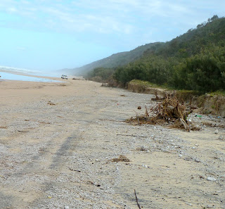
Following a couple of days in Rainbow Beach, we decided to return to Brisbane via Teewah Beach and the Tewantin ferry across the Noosa River. We accessed the beach along Freshwater Road from Rainbow Beach Road, and a most pleasant drive through the forest it was. But the beach looked vastly different from previous visits. Extensive mounds of pumice lay along virtually the whole of its 40 kilometres; there were large amounts of other debris ranging from small bits of plastic in a rainbow of colours to lengths of string to thongs, wooden flotsam and larger pieces of plastic. All in all, it wasn't pretty. Scum was the word that came to mind. On my beautiful Cooloola.
The beach had been badly eroded, too. The entrance to Red Canyon (below) used to be a gradual incline. Lots of Casuarinas lay uprooted and fallen on the sand. The foredune area had been inundated and in the undergrowth a wave of material extended along the highest tide mark. It reminded me of tsunami creep.
So, what was going on? Large ocean swells of up to 2.5 metres had combined with higher than usual tides (over 2 metres) over the weekend – and were expected to continue until midweek. The Department of National Parks (Recreation, Sport and Racing) issued an alert on Monday about conditions on the beach and in campsites. They estimated the pumice was up to 30 cm thick in places. There was another hazard to be negotiated on Noosa North Shore where much more coffee rock than usual had been exposed by the removal of sand. Fortunately, we were travelling down at low tide**.

Coolum Boardriders Club reported back at the beginning of April that they'd noticed a lot of pumice washed up on the beaches of both the Sunshine and Gold coasts as well as drifting offshore. They speculated that it had originated in underwater volcanic eruptions off Indonesia and in the western Pacific and had been carried south by ocean currents before being cast up on the beach by storm surges or large swells and tides. Some pieces had sea growths on them and others were quite round, suggesting they'd been around a while. While most of the pumice was light grey, some was black. Curiouser and curiouser.

The Queensland coast usually experiences damage to beaches during cyclones, when huge waves are generated by strong onshore winds. If large waves coincide with high tides then erosion is far greater. If a cyclone is severe, more than 400 cubic metres of sand per metre of beach may be removed and the beach recede by 50 metres.

But back to the pumice. I would like to know if there's been a pumice deposition like this before. And exactly where it's come from. And whether the Parks Department think it will gradually be removed back into the ocean. And whether all the sand eroded away will eventually be redeposited back on the beach or will visitors to Red Canyon need stepladders in future. I am on the case*.

Cooloola was, of course, still beautiful. But there was an awful lot of pumice.

Post script I contacted Queensland Parks & Wildlife Service, who were very helpful and consulted a coastal scientist on my behalf. He confirmed that pumice is commonly deposited on beaches. Local wind and wave conditions may result in concentrations on some beaches. The pumice may become buried in the dunes as they rebuild and then released during the next erosion event. There has been a lot of erosion in recent times in this region. On being shown the photograph of the dune scarp at the entrance to Red Canyon, he surmised that the pumice may well have come out of the scarp face. In the past he has seen pumice layers up to 150 mm thick in dune scarp faces.

** Get your tide tables here: http://msq.qld.gov.au/Tides/Tide-tables-2013.aspx
You cannot drive in Cooloola Recreation Area without a valid vehicle access permit: http://www.nprsr.qld.gov.au/recreation-areas/vehicle_access_permit_fees.html

This post was last updated on 1 June 2013


May 20, 2013

Cows and national parks

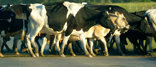
There are some people in Australia who want to see national parks opened up for hunters and shooters and now, cattlemen and their stock. The failure of monsoonal rains in Northern Queensland has created a situation in which increasingly hungry cattle are roaming on rapidly developing dust bowls. What is to be done?

The Queensland Government's solution is to let them into national parks to graze, an idea that hasn't gone down too well. The National Parks Association of Queensland is alarmed.
'National Parks are there to conserve our wild animals, plants and landscapes – not to be used as cow paddocks! This is a disturbing move, and currently would constitute a breach of the Nature Conservation Act.'
Federal Environment Minister Tony Burke has gone further, and said no. Another stand-off twixt Feds and State. Last year he stood in the way of the reintroduction of cattle into the Alpine National Park of Victoria.

The cattle farmers of northwest Queensland are not just suffering from a lack of rain. Cattle prices are low and farmers have not recovered their incomes since the temporary ban on live cattle exports to Indonesia in 2011. They allege that Indonesia still lacks confidence in the Australian beef market. Bush fires further added to their woes.

The national parks chosen are not necessarily national parks as we know them. Some may be former grazing lands purchased by the previous State Government since 2010 with a view to increasing Queensland's small percentage of land (compared with other states) given over to national parks. The National Parks Association called for these roughly 400,000 hectares to be gazetted as national parks earlier this month. But the State Government is dragging its feet until a 'scientific' review of all Queensland national parks is complete. That's 12.5 million hectares.

The areas currently earmarked to be used as temporary emergency feedlots are not easy to identify. It is claimed that five national parks and eight reserves are involved. One I have managed to identify is Blackbraes Resource Reserve. This was formerly Blackbraes Pastoral Holding, which was gazetted in 1998. A grazier from near Einasleigh in Northern Queensland has been told she can graze 1000 of her cattle on Blackbraes. (I have no idea what a Resource Reserve is, before you ask.)

There are many arguable aspects of the proposed grazing plan. Many national parks have not been adequately maintained and are overrun by invasive plants species. An uncontrolled undergrowth build-up provides 'fuel' for bush fires that decimate fauna and flora. In theory, grazing animals help to reduce weed infestations. The Government claims that what they are proposing will be a temporary measure, for six or 12 months, so damage by the cattle would be minimal. The RSPCA is in favour because of the animal welfare issues: 25,000 cattle may have to be culled if farmers cannot feed them.

Government-subsidised food could be dropped for starving cattle, but short-term temporary measures are not the answer. Greens Queensland Senator Larissa Waters claims the Government is not addressing the longer-term problems for graziers of climate change.

And then there are those who believe farming practices in Australia need complete overhaul in terms of fertility maintenance and water management. Peter Andrews, grazier and racehorse breeder, knows all about resuscitating run-down grazing properties and restoring fertility to parched land. He calls his methods natural sequence farming, and his book Back from the brink: how Australian's landscape can be saved should be essential reading for rural landowners.

There is no reason why responsible grazing cannot be combined with the successful conservation of Australia's rich biodiversity. It happens at Bimblebox Nature Refuge, for instance. Privately owned productive land has long been recognised for the important role it can play in landscape conservation and is at the heart of the National Reserve System*.

The current plight of Bimblebox illustrates, however, that even when corrective measures are in place, big bucks and weak governments combine to render them meaningless. Cattle and shooters roaming through national parks; mining companies devastating nature refuges; they amount to carelessness with this country's remarkable landscape.

* http://www.environment.gov.au/parks/nrs/about/protected-areas/index.html


May 7, 2013

May Day is Labour Day

Monday 7 May 2012 was Labour Day in Queensland and a public holiday. We had a lovely long weekend in Rainbow Beach.

Yesterday, Monday 6 May 2013, was an ordinary working day in Queensland. Labour Day has been moved to Monday 7 October, by Campbell Newman's government, ostensibly to bring us into line with New South Wales, South Australia and the Australian Capital Territory, and to spread out public holidays more evenly throughout the year.

May Day is traditionally a Northern Hemisphere event with its origins in pagan festivals. It is associated with the end of winter and the beginning of summer, with flowers and fertility, and it is certainly a cause for celebration, often exuberant. These celebrations take many forms: in the UK it's all about dancing with ribbons around maypoles, and May Queens, and baskets of flowers, and more dancing, this time by men wearing bells and baldrics.

In Australia, of course, it's coming on winter. There are, on the other hand, Morris men in every state.

May Day is also marching day, if it's Labour Day and since it's International Workers' Day. The latter originated in post-Civil War Chicago, when workers, many of them immigrants, fought for an 8-hour day. A new law was supposed to come into effect on 1 May 1886. The cause of those who died in the ensuing violence when it didn't materialise was shared with nascent workers' movements in Europe – and Australia – protesting for the rights of unions and immigrant workers. In the US shortly afterwards, a day celebrating the contribution of workers to society was designated later in the year (the first Monday in September) to disassociate it from Socialism, Communism, and the violence of the struggle.

The date of Labour Day in some countries reflects significant events in the history of the labour movement of those countries. It differs from state to state in Australia: in Tassie, for instance, it's the second Monday in March and is called Eight Hours Day. But for anyone of European origin, May Day is Labour Day. It's a strong tradition in Queensland, too. One of the first Labour Day/May Day marches ever held in Australia was in Queensland in 1891, in Barcaldine in the Central West. The Labour Day date started to be moved to different times of year in some states after the Second World War. But only now in Queensland. And the workers aren't happy.

The reasons are spurious. Why would Queenslanders care about being in line with the southern states? They stubbornly refuse to switch to Daylight Saving Time, so for half the year they're in a different time zone. The queen's birthday had already been moved from June to October by the previous State Government, evening out the holidays following a government discussion paper to which the public were invited to respond. But Newman has moved it back to where it was and moved Labour Day instead. Amendments to the Holidays Act (1983) were passed on 30 October 1012 without further public consultation.

So, in many parts of Queensland last weekend, marches and other traditional May Day events took place regardless of what many see as Newman's attack on workers' traditions. For many people in the labour movement, it's the final straw. Thousands of public servants have lost their jobs since he came to power, and now there's talk of public asset sales.

In Barcaldine, the annual Tree of Knowledge Festival saw hundreds turn out for, among other things, the goat racing. In Brisbane there was a march and a rally addressed by PM Julia Gillard. The Queensland Council of Unions claimed that tens of thousands marched, the biggest number in a decade. The Courier Mail, Queensland's only statewide daily newspaper, didn't see fit to even mention the rally or the PM's presence in its online edition yesterday. No need to tell you who the paper's owners are.

Some unions are so unhappy about the change of date that they're planning to protest on the new Labour Day in October and every subsequent May Day weekend until the holiday is reinstated. About 500 gathered noisily outside the State Law building in the CBD on Monday morning. Emotions ran high – and not just among drivers caught in massive congestion on their way to work.

And the name of the winning goat in Barcaldine? Rather appositely for the birthplace of the Labor* Party, it was Up the Mighty Worker. I kid you not.

* the Australian Labour Party was influenced by the American labour movement in its early years and changed the spelling in 1912. It was also considered useful to distinguish the Party from the Australian labour movement


May 4, 2013

A plea for Bimblebox

Waratah Coal's Supplementary Environmental Impact Statement (SEIS) was finally published on 8 April. Public comment has to be submitted by the end of Monday 6 May. Please make your feelings known if you do not approve of the wrecking of the unique ecosystem that is Bimblebox Nature Refuge to make way for yet another mega mine.

For more information about Bimblebox, go to http://bimblebox.org.

I would not expect many people to read the thousands of pages of SEIS, but you might like to dip into the Nature Conservation section. First go to https://waratahcoal.sharefile.com/d/s9c5d
9104048447e8. Then scroll down to VI  PART C 03 Nature Conservation. Unfortunately, it won't let me publish the direct link to this section.

There are many issues to consider apart from the obvious threat to the biodiversity of the Galilee Basin and the potential loss to the owners of Bimblebox who in 2003 invested – along with the Queensland State Government – in the conservation of the property.

• How can further exploitation of coal resources possibly be justified in the contexts of Australia's huge carbon emissions problem and the imminent serious impacts of climate change?
• Have exhaustive studies been conducted into the cumulative impact of several mega-sized mines on water resources in the region?
• The viability of continued large-scale mining for export to China and India is increasingly called into question by economists. Their reasons include the current economic slow-down and a movement away from fossil-fuel-based power generation in China. This is the time to pause for reconsideration, not hurtle down the same path, seduced by the allure of mining royalties and hence the possible reduction of Queensland's deficit.
• Biodiversity offsetting is not something to be used to pull the wool over people's eyes. Insufficient research is being done before an EIS or SEIS containing an Offset Strategy is submitted. At this stage it appears to be merely a proposal rather than field-based research to indicate that it is, in fact, perfectly feasible to replicate a unique desert upland ecosystem, complete with requisite fauna and flora, somewhere other than Bimblebox Nature Refuge. How exactly is the proponent's Strategy to be monitored to its realisation and into the future? And by whom?

These issues deserve much greater elaboration, but that will have to be for another occasion. There are, as I write, two and a half days until submissions close. At the following link is a pro-forma submission to help you to help Bimblebox:
http://bimblebox.good.do/SEIS/say-no-to-clive-palmer-s-massive-new-coal-mine-have-your-say-on-the-supplementary-eis-edit/.

Please seriously consider making a submission. Thank you.


May 3, 2013

Alexandria Bay

According to TripAdvisor, Alexandria Bay is by far Queensland's most popular nudist beach and has been used as such for years. Some weekends, allegedly, hundreds of clothing-optional fans gather on the beach for sporting activities. I'm glad they didn't do that on Anzac Day, however. We went there for some soothe-our-souls-oh-sublime-Aussie-beach time. It was quite crowded by our exacting standards, and there were enough porky middle-aged men hanging out, so we didn't need an Adamandeve Club carnival, too.

Alexandria Bay is on the eastern edge of Noosa National Park between Hell's Gates and Sunshine Beach to the south. You can walk to the northern end from the Park headquarters car park (turn right at the Hastings Street roundabout in Noosa Heads) where you can pick up a map of trails in the National Park. Alternatively, you can walk to A-Bay from Parkedge Road in Sunshine Beach, which is what we did. The forest soon opens out into coastal heath with Serrated Banksias, tweeting darting birds and tea-tree-coloured creeks.
How many more beaches I can rhapsodise about? I would understand if you said, 'Seen one, seen them all', but the thing is, they are so magnificent it's worth seeing them all. And they do have distinguishing features. A-Bay reminded me of Broken Head (NSW) in many respects, but it has a clearly defined stone zone that was rather attractive, if a little puzzling. I'd had either too little sleep or too much sun.
There were patterns and other interesting things to be found, as always: swirly dark mineral deposits in the creek; and curious ridges in the sand that we concluded were subterranean sand snail trails. Although A-Bay doesn't have a regular surf life saver presence, this was a public holiday so there were frequent visits from a spotter chopper, beach buggy and rescue boat. 
We walked to the northern end of the beach and back. The shadows were lengthening and the tide was coming in. Time to head back to Brisbane. Had this been the last beach day for a while?