February 16, 2013

A wild weekend in Ballina

It was Australia Day, but the weather prospects were grim for our long weekend on North Coast New South Wales. I knew most if not all of my pictures would be grey through rain-spatters. Can you have too much of a blue-sky thing?

It was oppressively overcast, but dry, all the way to the border and beyond. I could not ignore the signs to Byron where, after coffee at Twisted Sista (naturally), it started to rain. In Byron, you continue to walk in rain wearing next to nothing: that way you don't get wet clothes, I suppose. The beaches were deserted save for crazy kite surfers, but the streets were buzzing. The theme for the weekend was quickly established – hunkered down, disgruntled gulls.
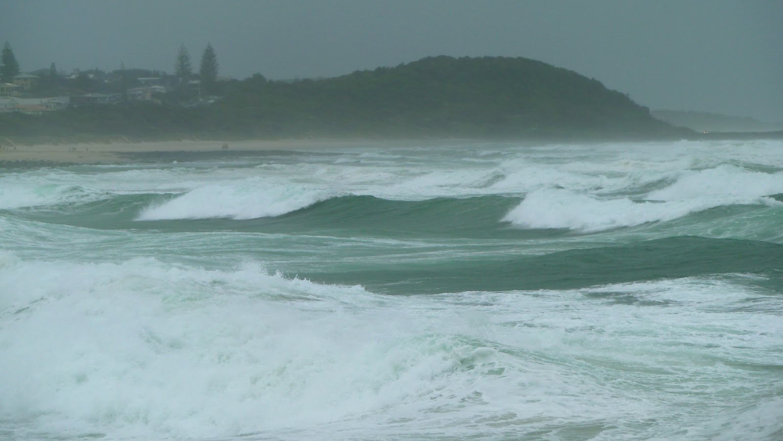
We didn't return to the highway, instead taking The Coast Road to Ballina. In true British fashion, we ate our lunch in the car on Lennox Head, peering blindly through the windscreen. The elements had to be battled, briefly, for the sake of photographing the angry sea. A little way down the road Sharps Beach was closed to swimmers. Two surf life savers huddled in their car: it was still school holidays, when they are on duty every day. The beauty of Sharps' immaculate beach could not be dulled by inclement weather: rocks were being blasted by sand-laden wind and rain.
By the time we got to Ballina, I was ready to retreat into a nice dry hotel room with my book. We were staying at historic Ballina Manor, which was a girls' school in the 1920s and later a boarding house but was scheduled for demolition by the turn of the century to make room for a block of units (Australian for flats or apartments). It was rescued and carefully restored: six former pupils of the North Coast Girls College, by then in their late 80s, attended the opening of Ballina Manor boutique hotel in 2000.

We were booked in for dinner that evening, so had no need to go anywhere. But it was only raining moderately and I knew it could only get worse. I felt duty bound to see something of the town while we could still walk around. So we waterproofed and went to Ballina North Wall, a breakwater on the north shore at the mouth of the Richmond River, one of New South Wales's great Northern Rivers. Most of the town fronts the river or North Creek – Fishery Creek effectively makes an island of central Ballina – but East Ballina has fine Pacific beaches. As we walked along the Wall, sand from Lighthouse Beach blasted any exposed skin, the waters across Ballina Bar churned ominously and I feared for my camera lens as I crouched in the lee of the breakwater's boulders.
Shelly Beach is shelly, as you might expect. I tried to imagine what it would look like on a bright sunshiny day.
Ballina Head Light* is short and dumpy, 760 km north of Sydney, and thinks it's called Richmond River Lighthouse. It was finally time to give up on Australia Day weather.
The next day the weather was just as bad. We had coffee by the river while deciding where to eat that night. The Point was showing the Australian Open men's final so that kind of decided it.
Just a bit further upstream in Fawcett Park, Joe Stark's fish and pelican sculptures were whizzing so fast in the wind it was difficult to focus.
I liked Ballina. I only wish I'd seen it in typical Australia Day weather. I'd liked to have wandered along the main drag – River Street – but it was just too wet and most shops were closed. The Pacific Highway used to pass through town along River and Kerr streets, but since 2010 a bypass and swanky flyover have enabled drivers to skirt around Ballina barely realising it's there. Which is just what we did a couple of years ago on our way back to Brisbane from the Waterfall Way.

Unfortunately few towns can escape the 'Australian ugliness': Ballina's pub, the Australian Hotel, is blighted by big yellow XXXX Gold signs, and the RSL lettering is so big it can probably be read from the space station. But never mind, watery Ballina, with its wide Northern River, creeks and beaches, is worth a visit. It caters for tourists and recreational fishers, and if you're a Sydneysider hellbent on Byron, then Ballina's airport is only 20 minutes away. There are commercial fishing villages further south, and that's where we were heading next.

* Lighthouses of Australia by John Ibbotson


February 14, 2013

Cutting green tape


I suppose it's fairly inevitable that Rick Wilkinson, Chief Operating Officer of the Australian Petroleum Production and Exploration Association (APPEA) Eastern Region, and Drew Hutton, President of the Lock the Gate Alliance, would not see eye to eye about how well the Queensland government performs when it comes to following public policy processes with respect to environmental protection.

On ABC Brisbane a couple of days ago both were asked to comment on allegations in Monday's Courier Mail that the Bligh (Labor) government rushed through major coal seam gas projects in Queensland, thus pressurising overworked public servants so that they were forced to compromise environmental regulatory procedures. The newspaper alleges, based on documents viewed following a right-to-information request, that in May 2010, as the approval process for the Santos GLNG project – an $18.5 billion coal seam gas processing plant* on Curtis Island near Gladstone – neared its conclusion, they were asked to process a similar proposal from QGC (Queensland Gas Company), worth $16 billion and also on Curtis Island. Then along came APLNG (Australian Pacific LNG, a joint venture between Origin and ConocoPhillips), which was approved by November.

The Mail reports that, just days before QGC got the go-ahead, the assessment team reported they still didn't have details of pipelines or the locations of wells, and that many environment issues had not been analysed. Since the CSG industry will be worth $45 billion at its peak this year and employ 21,000 Queenslanders, it's not surprising that Campbell Newman's state government is keen to underline its confidence in the approval process and deny environmental damage. Have any of them been to Gladstone recently? In addition to sick fish and dead turtles and dugongs, there are now mutant cane toads**. Researchers are still puzzling over the cause of the extra-legged amphibians, but they might be wise to start with the contaminants dredged up during the deepening of channels in Gladstone Harbour in readiness for the liquefied gas tankers.

The projects were approved with many conditions for environmental protection attached, but the Courier Mail prints extracts from emails sent by senior public servants with serious concerns about procedures. One in the Queensland Co-ordinator General's office complains that their response to GLNG's Environmental Impact Statement (EIS) was 'rushed, insufficiently transparent, altered and lacking key impact assessment'. Many more worrying concerns were expressed: read the article at http://www.couriermail.com.au/ipad/public-servants-tasked-with-approving-to-massive-csg-projects-were-blindsided-by-demands-to-approve-two-in-two-weeks/story-fn6ck45n-1226574981202.

Meanwhile, on the ABC on Monday, Mr Wilkinson was at pains to describe how long the environmental approval process took, likening it to the time it took to put his daughter through high school. Surely not? He denied that there had been any environmental damage, while Mr Hutton described the 'spa bath' Condamine River, bubbling with escaping coal seam gas, and the blighted lives of people living in the coal seam gas fields of the Western Darling Downs.

Since the LNP government came to power in Queensland nearly a year ago, they have been working towards streamlining approval processes and doing away with duplication between state and federal environment departments. Many activists, Greens and nature lovers, of course, believe scrutiny should be even greater, with bureaucrats relieved of any pressure to pursue a 'bankable outcome' rather than one that conserves Australian biodiversity.

* coal seam gas is processed in a gas-liquefaction plant ready for export
*http://www.smh.com.au/national/industrial-city-gives-birth-to-mutant-toads-as-queensland-researchers-look-for-cause-20130211-2e8zj.html


February 10, 2013

Bimblebox 7: 2013 prospects


Federal Environment Minister Tony Burke has just rejected the Australian Heritage Council's recommendation that 493,000 hectares of the Tarkine region in Tasmania's northwest be included on the National Heritage List. Instead, a mere 21,000 hectares of coastal strip will be added, for its Aboriginal cultural heritage. Mr Burke claims that this was one of the toughest decisions of his career*, but he couldn't agree to the Heritage Council's request at the expense of jobs in a region where unemployment is considered a big problem.

Several mining projects, including tin and magnetite mines, are planned for this area of temperate forest wilderness (above), with its Tasmanian Devils that have not yet been decimated by facial tumour disease and – who knows? – maybe even a Tasmanian Tiger. Interestingly, I have just read that in Cornwall (UK), once a famous tin-mining region, there are plans to dredge sand just off the county's north coast in search of remnant traces of tin**. Cornwall's north coast is a surfing mecca – yes, it really is, should Aussie surfies of the Gold and Surf coasts doubt it – and has a massive tourism industry based on spectacular beaches. 'Tis a brave council that threatens surfers' favourite waves.

Mr Burke's decision making is disappointing, and I have little faith in him to resist the mining plans still on his desk. His position is complicated by Julia Gillard's recent announcement of the date of the next Federal election. Given that the majority of political pundits give Labor a slim chance of re-election on 14 September, does Tony Burke grab a brief yet noble window of opportunity to protect this continent's biodiversity and tackle its carbon emissions problem? He could reject weak Environmental Impact Statements (EISes) that
pay lip service to environmental protection and glibly cite unproven offsetting schemes. Or does he approve mines and power stations and rail corridors and port facilities in the hope that his government can use resource taxes and export revenues to bolster its forecasts of a budget surplus?

The data concerning the destruction of Bimblebox Nature Refuge by an opencast coal mine proposed as part of Waratah Coal's China First project sits in Mr Burke's pending folder. It awaits further information, in the form of a supplementary EIS. It is several weeks since environmental scientists in the employ of Waratah last visited Bimblebox to spuriously list fauna and flora for offsetting purposes. Any ecologist worth his or her qualification must know that they are attempting the impossible: you cannot offset a unique ecosystem. Or, at least, not without years of R&D and many more of growth and establishment.

I firmly believe that the fate of Bimblebox is subject to the whims of the international market for coal. There are many rumours coming out of China, not only concerning the health of its economy but also the desire of China's leaders to generate power from clean energy sources given the current risks to the health of its citizens. Beijing spent much of January blanketed in acrid smog, air quality falling short of World Health Organisation safe limits every day of the month. According to the World Bank, China has 16 of the world's most polluted cities. Decreasing numbers of blue sky days prelude chronic illness, intellectual impairment and behavioural problems later in life for today's children.

In Australia, the transition from coal to renewables is much more a question of cost than the desire to reduce the nation's massive carbon footprint. The Sydney Morning Herald's 'carbon economy editor', Tom Holland, writing in the paper only a few days ago†, doesn't believe any more coal-fired power stations are likely to be built. Given reduced demand for energy and falling costs of wind and solar power generation, big banks see fossil fuels as an increasingly risky investment.

There is, however, a plan†† to build a 'clean' coal-fired power station between Alpha and Bimblebox to supply energy to mines in the Galilee Basin. The proponent is a subsidiary of Waratah Coal. Please note that submissions are still open (until 22 February).

Submissions close tomorrow for yet another Galilee Basin mega mine. The Carmichael Coal Mine and Rail Project, 160 km northwest of Clermont, would be the largest mine in Queensland, extending for at least 40 km and, like Waratah's China First, obliterating remnant desert upland, cattle stations and a nature refuge. The proponent is Adani Mining Pty, a subsidiary of the Indian Adani Group, which intends most of the coal for export. Adani face corruption charges in India, allegedly failing to pay sufficient tax on its iron ore exports, while its record of compliance with environmental regulatory procedure is poorª.

There is little doubt that an LNP federal government, together with resource-rich, like-minded state governments will make violation of the Australian landscape easier. They will do away with carbon pricing, thus encouraging fossil fuel-based energy generation, and hand over greater environmental control to the states. May all your gods help Queensland, and especially Bimblebox, should that day dawn in September.


February 7, 2013

Who pays?

Mayor Graham Quirk has announced that the clean-up bill for Brisbane post-Oswald will be in the order of $60 million. Who will pay, and for which bits? In Central Queensland the bill will be far higher. Major infrastructure has been destroyed; thousands of farmers have lost their homes and livelihoods; fishing boats were swept away and left high and dry and stranded.

Millions of dollars' worth of coal exports are likely to be lost because of damage to the rail line to the port of Gladstone. Will the mining companies help pay for repairs? Coal production raises another problem in the form of huge quantities of contaminated water to be disposed of post flood. The coal companies expect to be able to dump at least some of their waste water in rivers, which then carry pollutants as well as silt and debris out to the Reef. Should taxpayers foot the bill for this part of the clean-up?

Mayor Quirk revealed that Council would only be able to recoup half of the $16 million it needs for road repairs, and none of the $13 million it needs to restore parks. He estimated that Brisbane Council would have to find about $23 million in total – ultimately from ratepayers.

It seems that last December revisions were made to 'national disaster guidelines' that determine whether the Feds or state or local government pay the bills for recovery after a catastrophe. Many local council leaders believe they are now liable for the replacement of social infrastructure. So, higher authorities pay for the big stuff such as roads, rail lines, bridges and culverts; while local government has to repair parks, sports grounds and facilities, children's playgrounds, public toilets and the like.

In fact, there is still a certain amount of flexibility as far as who pays for what is concerned, if the Feds and the state government are inclined to put their heads together to create a National Partnership Agreement (NPA). Over the last few days state Treasurer Tim Nicholls (Liberal National Party) and Federal Minister for Flood Recovery (and Senator for Queensland) Joe Ludwig (Labor) have been bickering about who has contacted whom in an attempt to launch an NPA. I hope the ruined citrus growers of North Burnett aren't listening to their politicking.

If parts of Australia are to become even more at risk from flooding rains – and there can be little doubt, unless you're an ostrich – not only should 'disaster' funds be included in budgets at national, state and local levels, but guidelines under the National Disaster Relief and Recovery Arrangements (NDRRA) need revision. They should not be restricted to replacing like with like. That is why the town of Gayndah has lost its water pump twice in two years. The next one must surely be built well away from the Burnett River. Following the 2011 floods, the citizens of Grantham were rehoused on higher ground, which must seem like a good plan to most people. The resolution of most if not all big issues, however, comes down to cost, and, with politicians obsessing about budget surpluses and the looming election, I pity those poor Queenslanders awaiting speedy and innovative rebuilding programmes.


February 5, 2013

Déjà vu

In the days following Oswald weekend, evidence of devastation and appalling loss gradually became apparent. Many communities were isolated by severed communications, and flood waters took time to recede, so damage assessment was tardy. It is now clear that, for some regions, the impact of this natural disaster was greater than that of the floods of 2010-11.

Arriving home in Brisbane late last Monday night, we immediately spotted three mature trees felled within 150 metres of our apartment block, and extensive piles of branches broken off other trees that had remained standing despite wind gusts in excess of 100 km/hr.

Next morning I walked through New Farm Park, which was 'closed' as men with chain saws and giant wood chipping machines cleared away the evidence of Oswald's crazy rampage. I was sad to see the demise of one of the Park's fine Queensland Bottle Trees. I sat by the brown river waiting for high tide at around 11: it wasn't as high as predicted or the previous high-water line of debris. I noticed the same phenomenon I'd seen in 2011: the tide coming in at each side of the river as flood waters charged downstream in the centre of the channel. As the streams of water flowed past each other curious short-lived eddies were created.
There were, of course, no City Cats or cross-river ferries because of debris hurtling down river. How unnaturally quiet the river seemed, apart from the odd craft involved in the clean-up. Even tugs going upstream struggled against the flow. A seagull floated backwards midstream at considerable speed but seemed unperturbed.
The majority of Brisbane's citizens are not 'doing it tough' following ex-Cyclone Oswald: the worst most people had to put up with was a loss of power for a few hours. More badly damaged were upland communities north and south of the city such as Mt Glorious and Mt Tambourine. Further north in Central Queensland, things were very much worse. Some residents of Bundaberg weren't even allowed back to look at the ruins of their homes until a week after the event. What they found was enough to break the strongest spirit.

Brisbane and the towns of the Lockyer Valley were not the only communities hit in the 2010-11 floods, either, although they garnered many more column inches. Then the region through which the Burnett River flows suffered greatly, as it has just done again. North Burnett is rich agricultural country, known in particular for its citrus trees. The mayor of the North Burnett Regional Council was already working with the Queensland government to help citrus growers hit by severe hail storms just before christmas. Now there are few trees left standing. More than 100 farms were completely washed away: thousands more have been substantially damaged and face formidable reconstruction of fencing and irrigation systems. The town of Gayndah commissioned its new water supply pump system just four weeks before Oswald struck: it was destroyed by the swollen Burnett River, leaving the town without water.

The extraordinary stoicism of the people of this region has to be seen to be believed. Deputy Premier Jeff Seeney toured the area – he represents the constituency of Callide and is Minister for Infrastructure and Planning – and stressed the need for a drastic rethink of rebuilding programmes for flood-prone areas following natural disasters. And I agree with him. Governments cannot fund reconstruction to the tune of billions of Australian dollars, only to have it destroyed two years later. I wonder if Mr Seeney is thinking what I'm thinking, however: that not only is it a colossal waste of taxpayers' money but that such extreme weather events will be more frequent in decades to come and prime agricultural land and infrastructure have to be better protected.

This post was last edited on 14 February 2013


February 1, 2013

When is a tropical cyclone not a tropical cyclone?

The answer is simple: when it's over land.

This morning the ABC's Steve Austin invited Senior BOM* Meteorologist Rick Threlfall – who's from my neck of the woods in the North of England, except he supports the wrong football team – to answer an important question. Where did Oswald get its energy from if it wasn't absorbing moisture from a warm ocean?

In Far North Queensland, Rick explained, Oswald the low-pressure system was driven by the northern monsoon trough (which arrived late this year, I know for a fact, and obviously wished to make its presence felt now it was here). 'It developed a fair bit of spin,' Rick embellished, and high humidity meant lots of moist air rose rapidly and then condensed. Cairns copped it.

As Oswald moved south there was an extratropical transition. An upper trough (different from the northern monsoon) interacted with Oswald the low-pressure system, feeding off the high degree of moisture in the atmosphere once again (90-100 per cent humidity). The system then sat over Queensland's eastern highlands for about 24 hours, during which moisture was sucked up and condensed, then dumped over North Burnett and Bundaberg, and as it moved on south.

The huge amounts of rainfall and extremely strong winds over South East Queensland and northern New South Wales were the 'very same ingredients' as you would get in a category 1 tropical cyclone, Rick conceded. Possibly even a category 2, by definition. Technically, that's what we experienced: we just can't call it that because it was over land. That's the rule.

Thank you, Rick Threlfall, for setting the record straight.

I think I'm obsessing about Oswald.

* Bureau of Meteorology
This post was last edited on 2 February 2013