On Australia Day back in January, we headed southwest from Brisbane along the Cunningham Highway. We turned off for Moogerah Peaks National Park on what was probably only our second foray out of the city. But the highway continuing south beckoned, as did thoughts of what lay beyond the rugged peaks of the Scenic Rim. This barrier was not easy to cross until halfway through the 20th century: in 1949 a sealed road through Cunningham's Gap finally linked the Moreton Bay hinterland with the farmland west of the Great Dividing Range. It was named after English explorer Allan Cunningham who had first spotted a potential gap through these highlands in 1827.
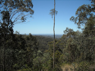
I'd like to show you a photograph of the two peaks standing guard either side of that gap or the view back over the Fassifern Valley, but as the highway climbed from Aratula, what had started out a grey and unimpressive day took a turn for the worse. The thermometer in the car recorded 13.5 degrees as we pulled into The Crest car park in low cloud and what the Basques called chirimiri, which looks like fine drizzle but will more than likely soak you through.
We were determined to do the walk I had planned because the rainforest covering much of Mount Cordeaux would shield us from the worst of the weather... was the theory. And I was keen to see giant spear lilies on the cliffs above the forest. We climbed a muddy, zigzagging path through dense forest that was as interesting as ever; Hoop Pines with their distinctive bark; enormously tall trees that we couldn't begin to identify because their foliage was too high up in the canopy;
slow-growing Grass Trees and super-glossy (in the rain) Piccabeen Palms; moss-covered boulders and fern-filled gulleys. Where the Grass Trees were, the rainforest morphed suddenly into eucalypt forest.
As the forest got thinner we got wetter, and we were on the point of giving up, but something drove us on. Five minutes further up the path were the giant spear lilies. Some were past their best, but we did see a few of these scarlet heavyweights - I could hardly hold one in position for my friend to photograph. We were too wet by now to continue climbing in the hope of seeing more and we had to get back on the road to Warwick.

As the Cunningham Highway dropped down to the still-high open country of the Southern Downs, the clouds lifted and there was even the odd blue bit. This is fertile dairy and grain country: much of the tumpy pasture was patched with purple and yellow flowers. But the smallholdings looked ramshackled and slightly trailer-park: there seemed to be bits of rusty machinery abandoned profusely. Before reaching Warwick we joined the New England Highway which runs from Yarraman, north of Toowoomba, way down into New South Wales. The highway goes straight through Warwick and so did we, preferring to press on to the Granite Belt wineries.
The land rises again steadily as you drive south, grain and meadow giving way to orchard and vine. We were headed first for Summit Estate Wines in Thulimbah. We knew already that some of their wines are quite palatable – my friend had sampled them at the Ekka. But the cellar door experience was not, it transpired, that welcoming or helpful. Chilly, I would say, by Australian standards.
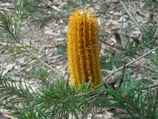
Bud-burst at Summit Estate
Vines and apple trees

Much more enjoyable was Boireann, well worth the drive down Donnelly's Castle Road at The Summit (so called, of course, because it's the highest point in these parts). This is a small winery that is highly thought-of – the best in the Granite Belt according to wine expert James Halliday, and he should know. A variety of red grapes are cultivated here in the fine granitic sandy soils at an altitude of 875 metres. We sampled some of the end product in relaxed surroundings while chatting to winemaker Peter Stark, but unfortunately couldn't get our hands on the much-acclaimed Shiraz Viognier (96 points in Halliday's Australian Wine Companion).
There was something very pleasing about the juxtaposition of vine and granite, and beautiful gardens by the cellar door looked just as carefully tended as the grapes must be.
Then it was down the road to Stanthorpe and a bit further on to Ballandean where we were spending the night in the delightful Vineyard Cottages, just as you drive into town. We relaxed in our large and pleasant open-plan room before dining in their Vineyard Cafe restaurant. I chose new-season asparagus and pork with winter vegetables; my friend had pork rillettes and steak. All the wines were local: we enjoyed a Tobin cab sav. We then shared flourless chocolate cake with salted butter caramel ice cream. The food was almost faultless.
The next morning the weather was much improved and, after a delicious breakfast, we enjoyed our beautiful surroundings – impressive gardens and distant views to the Sundown National Park – from the verandah for a while before moving on. There were Superb Fairy Wrens darting hither and thither and countless bees busy among the flowers and herbs. The wisteria (which grows all over this region) and miniature roses made us feel at home!
As we drove through Ballandean we turned off randomly on to Eukey Road and ended up driving through some beautiful countryside. My friend spotted a goat on warm granite.
We came across Symphony Hill, a modern 'boutique' winery that's family-run and friendly. We were particularly interested in the Halliday-mentioned Wild Child Viognier (great name). We beat a hasty retreat with our purchases when a coach party turned up on this quiet, still-early Sunday morning. We drove on to the Storm King Dam before turning back to Ballandean.
I have to deviate briefly at this point to discuss the use of the word 'dam'. Here is a brief passage from Gregory's Discovering Brisbane and Surrounds to illustrate my problem: 'the dam is stocked with native fish, including perch, silver perch and Murray cod'. Now, the fish aren't in the dam, are they? They're in the lake created by the dam. At Storm King Dam we couldn't see a dam, although I assumed from the name that the lake before us had been formed by damming a river. When we were in Northern Queensland earlier in the year, we were recommended to go visit a dam. How quaint, I thought at the time: how did they know my friend is an engineer. But what they meant was a lake, right?
Next up was Ballandean Estate Wines, a fair old way down Sundown Road. Unfortunately the coach party had caught up with us again and everyone at the winery was a bit distracted by the hordes, who unfortunately were about to take over the restaurant, so we couldn't have lunch. We had a wander round outside until we could get to the cellar counter to buy a couple of bottles of wine (including more Viognier) and food supplies, including local apple juice, from the deli for a picnic lunch somewhere else.
I have been trying to identify this parrot. It doesn't match any of the parrots in our bird book. I wondered if it could be a rare Turquoise Parrot, which looks different in every picture on Google. Can anyone help me?
Olives are also grown in the Granite Belt, the dark green of which reminded me longingly of Spain.
Our next destination – Girraween Environmental Lodge – is about 15 minutes south of Ballandean, just off the New England Highway along Pyramids Road. Although not in Girraween National Park itself, this delightful haven is set in about 400 acres of forest and bush complete with its own dramatic granite outcrops, walking tracks and wonderful wildlife. We had a two-bedroom wooden cabin (made largely from recyled timber) with a large deck and BBQ, a wood-burning stove inside and a bathroom big enough for a party. It was toasty warm and snug, with everything we needed, including silence (apart from frogs and birds) and serenity. No mobile or TV coverage thankfully.
The view from the deck
We soon threw our original plan – to visit the information centre up the road to plan tomorrow's walk in the Park – out of the window. There was too much on offer right where we were. We headed out on the Bird Walk but were immediately distracted by the most Eastern Grey roos I've seen at one go (there's a large resident mob on GEL's land). We hated to disturb them but they didn't seem to mind us quite close. Several females had joeys in pouches, and there were lots of 'roolettes' not long since left others', I suspected.
As long as I live in this country, I can't imagine becoming blasée about roos. Call me a big softie Pom who's batty about animals; I don't care. They amuse me; I like the way they stand up and look a bit spooked as if to say, 'Here they are again'. And I love the way they move, whether it's scratching or bounding.
The Bird Walk is a short amble through largely eucalypt forest edging Ramsey Creek. There are Blue Gum, Blackbutt and Stringybark, and Girraween also has many species of Acacia (Wattles), Black Cypress Pine and Kurrajong, with heath plants forming an understorey in places. We didn't see many birds apart from a few unidentifiable darters, oh and a Kookaburra sitting in an old willow tree.

At the end of the walk was a perfect picnic site. I'm not sure exactly what made it quite so appealing: a babbling brook chaosed with granite boulders; a splendid old Stringybark; a billy ready for boiling water for tea; a pile of wood for the fire; peace and quiet... I suppose this was my idea of the Australian bush experience. Shame we had no tucker with us.
We combined this walk with the Echidna Rock Circuit. I couldn't see the resemblance myself but the balancing rock was impressive nonetheless. As were some of the wildflowers (Stypandra glauca, or Nodding Blue Lily, below but one).
We wandered back to our cabin. While drinking tea on the deck we spotted a lot of bird activity just below us in a Grevillea bush. The honeyeaters couldn't keep away, although the Yellow-faced honeyeaters and smart Eastern Spinebills respectfully took turns otherwise there were squabbles.
Our basket of BBQ goodies was delivered just as my friend was getting hungry, so he upped and manned the barbie forthwith while I faffed about in the kitchen. We had steak and sausages and sauté potatoes and carrots and beans and local wine, and every morsel was to savour. No sitting back after dinner, however: we were off to listen to the frogs for which this area is famous (as well as granite and wine). Pobblebonk is without doubt the best name for a frog I've ever heard: this creature literally goes 'bonk', quite clearly, just a single 'bonk' at a time. Other varieties have great names, too: there's the Red-groined Toadlet and the Eastern Sign-bearing Froglet. Owls don't do too badly for names either: the Powerful Owl is the biggest owl in Australasia, while the Boobook is the smallest, and most common, in Australia.
I could scarcely concentrate on the bonking for looking up to the heavens. Pause for a moment of respectful reflection: the Milky Way was... indescribable. Better than wondrous, astonishing, breathtaking, stunning, extraordinary... all of those, and more. Just as well it clouded over after a while: I would have been there for hours, in total black, gazing in amazement at a canopy of myriad pinpricks of ancient light.
I slept so well I didn't even hear the Kookaburras' wake-up. It was a beautiful morning: it had to be. We were soon up and out because we wanted to catch joeys out of pouches, playing, but we weren't in luck. We had to take a detour to reach them because of a most disturbing encounter with a Masked Lapwing, also known as a Spur-winged Plover. While stumbling about the previous evening looking for frogs, we had inadvertently spotlit a family of Lapwings with their three chicks. This grass forager lays its eggs in a shallow scrape on the ground and is famous for its ferocity when defending its young and is armed with wing spurs. But how good is its memory? It was as if it had recognised us and was set on retaliation as it flew straight at us, fast. We had to dive out of the way.
Far too much excitement so early in the morning: back for a barbie-cooked breakfast to set us up for a walk.
We had to leave early to maximise our time in the Park, but I could happily have stayed a lot longer at our tranquility base. The thought of coming here midweek, when there's hardly anyone around we were told, is an appealing prospect. As we said our goodbyes to GEL's amiable manager Jonathan Marr, we received some instruction on wattles. The amazing specimen below had spring- and sea-green leaves with purply pink seed pods. (The golden wattle is Australia's national emblem.)
Jonathan also told me a fascinating thing about Eucalyptus. Blue Gum, or 'River Blue Gum', is known as Red Gum, or 'Forest Red Gum', when it grows on hills and ridges away from rivers and watercourses, even though it's the same species. Eucalypts can change their form, shape and colour according to variations in climate, soil, elevation, aspect and so on. Some of them grow as a low prostrate under some conditions and as huge trees in other locations.
A couple of minutes down the road was the Girraween National Park information office where we procured a book on wildflowers and got help identifying other plants I'd photographed so far. Girraween is an Aboriginal word meaning place of flowers which is rather apposite because we came across these before we'd even started walking.
 Between 200 and 400 million years ago, tectonic plate collisions resulted in ocean sediments being thrust up over the area of continental Australia now known as the New England Tablelands, which lie mainly in northern New South Wales but extend into southern Queensland (Bald Rock National Park is an extension of the Girraween landscape in northern NSW). In addition, molten rock upwelled from the earth's depths, forcing its way into this sedimentary bedrock before cooling to form granite. Over time the sediments were eroded and the granite exposed.
Allan Cunningham was the first European to come to the Girraween area (1827). As a botanist, he must have been delighted with what he found, although the difficult terrain meant his stay was rather short. From the 1840s onwards loggers and farmers settled, and from the 1930s on various pockets of land became protected by declaration of national park status. By 1980 the final pieces of the jigsaw land acquisitions had increased Girraween National Park to the size it is today (nearly 30,000 acres).
The Junction had been recommended as the best walk for spring flowers. This was easy going for about 5km along the northern bank of the Bald Rock Creek to where it meets Ramsay Creek. There were rock slabs and boulders everywhere.
The whole landscape was extremely pleasing as the path wound through the trees. We spotted Scarlet Robins and Crimson Rosellas and some birds we still haven't been able to identify. We sat by the babbling brook to eat our lunch of barbecue leftovers. It was alternately cloudy and sunny, but we did at one point have to crouch beneath a boulder to escape a passing shower. We hadn't taken waterproofs, having been assured by the information office that the weather was clearing completely. Why is it so difficult to get weather forecasting right in Australia?
Not having had quite enough of walking by the time we were almost back at the start, we made a short detour to the Granite Arch, an impressive natural stone archway.
We couldn't even walk back from there to the car without being further waylaid.
And this joey looked as if it had got into the pouch in a hurry.
It's a three-hour drive from Brisbane to Girraween so it is not beyond the realms of feasibility to come down here for a weekend. And I intend to do just that – perhaps to escape summer in the city. Unlike on the outward journey, our climb towards Cunningham's Gap was bathed in golden evening light and as we descended into the Fassifern Valley there was a striking sunset skyline.
This post was last modified 1.8.2011